Racconigi geodata
Racconigi (Piedmont) is a seat of a third-order administrative division; located in Italy in Europe/Rome (GMT+2) time zone. With population of 9,156 people, there are 1036 cities with bigger population in this country. Compared to other cities in Italy, 55.6% of cities are located further ↓South; 96.4% of cities are located further →East and 55.6% of cities have lower elevation than Racconigi. Note1


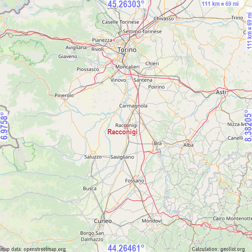
Racconigi GPS coordinates[2]
44° 45' 57.528" North, 7° 40' 44.148" East
| Map corner | latitude | longitude |
|---|---|---|
| Upper-left | 45.26303°, | 6.9758° |
| Center: | 44.76598°, | 7.67893° |
| Lower-right: | 44.26461°, | 8.38205° |
| Map W x H: | 111×111 km | = 69×69mi |
| max Lat: | 47.04031° ⇑44.4% North |
| Racconigi: | 44.76598° |
| min Lat: | ⇓55.6% South 35.50142° |
| min Long | Racconigi | max Long |
| 6.69888° | 7.67893° | 18.48682° |
| W 3.6%⇐ | ⇒96.4% E |
Elevation
Elevation of Racconigi is 269 m = 883 ft, and this is 37.7 m = 124 ft below average elevation for this country.
| Max E: |
2085 m = 6841 ft | 44.4% |
| Avg. | 306.7 m = 1006 ft | |
| Racconigi | 269 m = 883 ft | |
Min E: |
-4 m = -13 ft | 55.6% |
See also: Italy elevation on elevation.city.
Geographical zone
Racconigi is located in North temperate zone (between Tropic of Cancer and the Arctic Circle). Distance of this Northern Tropic circle is 2371.6 km =1473.6 mi to South.| Distance of | km | miles | from Racconigi |
|---|---|---|---|
| North Pole | 5029.6 | 3125.2 | to North |
| Arctic Circle | 2423.7 | 1506 | to North |
| Tropic Cancer | 2371.6 | 1473.6 | to South |
| Equator | 4977.5 | 3092.9 | to South |


Nearby cities:
15 places around Racconigi: (largest is in red/bold)
• Caramagna Piemonte
5.1 km =3.2 mi,  69°
69°
• Carmagnola
9.9 km =6.2 mi,  19°
19°
• Casalgrasso
7.2 km =4.5 mi,  323°
323°
• Cavalleri-Fumeri
9 km =5.6 mi,  34°
34°
• Cavallerleone
3.1 km =1.9 mi,  202°
202°
• Cavallermaggiore
6.7 km =4.2 mi,  174°
174°
• Faule
8.7 km =5.4 mi,  301°
301°
• Lombriasco
9 km =5.6 mi,  337°
337°
• Murello
6.3 km =3.9 mi,  255°
255°
• Piobesi Torinese
4.9 km =3 mi,  270°
270°
• Polonghera
7.7 km =4.8 mi, 301°
• Ruffia
8.9 km =5.5 mi,  221°
221°
• Sanfrè
9.9 km =6.2 mi,  99°
99°
• Sommariva del Bosco
8.2 km =5.1 mi,  84°
84°
• Villanova Solaro
9.2 km =5.7 mi,  244°
244°
Sources, notices
• [Note1] Compared only with cities in Italy existing in our database
• [Src1] Map data: © OpenStreetMap contributors (CC-BY-SA)
• [Src2] Other city data from geonames.org with taken over terms of usage.
• [Src3] Geographical zone / Annual Mean Temperature by Robert A. Rohde @ Wikipedia
