Fresonara geodata
Fresonara (Piedmont) is a seat of a third-order administrative division; located in Italy in Europe/Rome (GMT+2) time zone. With population of 325 people, there are 10574 cities with bigger population in this country. Compared to other cities in Italy, 55.8% of cities are located further ↓South; 85.6% of cities are located further →East and 62.8% of cities have higher elevation than Fresonara. Note1


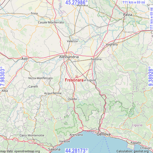
Fresonara GPS coordinates[2]
44° 46' 58.62" North, 8° 41' 10.14" East
| Map corner | latitude | longitude |
|---|---|---|
| Upper-left | 45.27986°, | 7.98303° |
| Center: | 44.78295°, | 8.68615° |
| Lower-right: | 44.28173°, | 9.38928° |
| Map W x H: | 111×111 km | = 69×69mi |
| max Lat: | 47.04031° ⇑44.2% North |
| Fresonara: | 44.78295° |
| min Lat: | ⇓55.8% South 35.50142° |
| min Long | Fresonara | max Long |
| 6.69888° | 8.68615° | 18.48682° |
| W 14.4%⇐ | ⇒85.6% E |
Elevation
Elevation of Fresonara is 143 m = 469 ft, and this is 163.7 m = 537 ft below average elevation for this country.
| Max E: |
2085 m = 6841 ft | 62.8% |
| Avg. | 306.7 m = 1006 ft | |
| Fresonara | 143 m = 469 ft | |
Min E: |
-4 m = -13 ft | 37.2% |
See also: Italy elevation on elevation.city.
Geographical zone
Fresonara is located in North temperate zone (between Tropic of Cancer and the Arctic Circle). Distance of this Northern Tropic circle is 2373.5 km =1474.8 mi to South.| Distance of | km | miles | from Fresonara |
|---|---|---|---|
| North Pole | 5027.7 | 3124.1 | to North |
| Arctic Circle | 2421.8 | 1504.8 | to North |
| Tropic Cancer | 2373.5 | 1474.8 | to South |
| Equator | 4979.4 | 3094.1 | to South |


Nearby cities:
15 places around Fresonara: (largest is in red/bold)
• Basaluzzo
2.2 km =1.4 mi,  136°
136°
• Bosco Marengo
4.6 km =2.9 mi,  353°
353°
• Capriata d'Orba
6.1 km =3.8 mi,  176°
176°
• Casal Cermelli
7.5 km =4.7 mi,  320°
320°
• Castelspina
8.5 km =5.3 mi,  287°
287°
• Francavilla Bisio
6.4 km =4 mi,  146°
146°
• Frugarolo
6.3 km =3.9 mi,  356°
356°
• Litta Parodi-Cascinagrossa
10.3 km =6.4 mi,  11°
11°
• Mandrogne
10.1 km =6.3 mi,  28°
28°
• Novi Ligure
8.3 km =5.2 mi,  105°
105°
• Pasturana
6.1 km =3.8 mi,  125°
125°
• Pozzolo Formigaro
7.9 km =4.9 mi,  76°
76°
• Predosa
4.3 km =2.7 mi,  213°
213°
• Sezzadio
9 km =5.6 mi,  271°
271°
• Tassarolo
9.1 km =5.7 mi, 132°
Sources, notices
• [Note1] Compared only with cities in Italy existing in our database
• [Src1] Map data: © OpenStreetMap contributors (CC-BY-SA)
• [Src2] Other city data from geonames.org with taken over terms of usage.
• [Src3] Geographical zone / Annual Mean Temperature by Robert A. Rohde @ Wikipedia
