Basaluzzo geodata
Basaluzzo (Piedmont) is a seat of a third-order administrative division; located in Italy in Europe/Rome (GMT+2) time zone. With population of 1,891 people, there are 4335 cities with bigger population in this country. Compared to other cities in Italy, 55.6% of cities are located further ↓South; 85.4% of cities are located further →East and 62% of cities have higher elevation than Basaluzzo. Note1


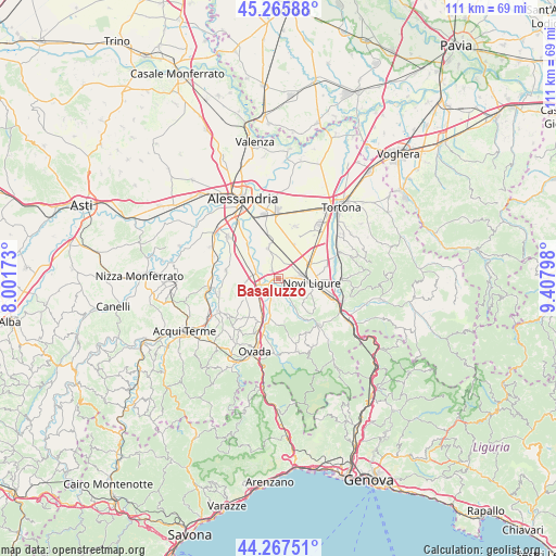
Basaluzzo GPS coordinates[2]
44° 46' 7.86" North, 8° 42' 17.46" East
| Map corner | latitude | longitude |
|---|---|---|
| Upper-left | 45.26588°, | 8.00173° |
| Center: | 44.76885°, | 8.70485° |
| Lower-right: | 44.26751°, | 9.40798° |
| Map W x H: | 111×111 km | = 69×69mi |
| max Lat: | 47.04031° ⇑44.4% North |
| Basaluzzo: | 44.76885° |
| min Lat: | ⇓55.6% South 35.50142° |
| min Long | Basaluzzo | max Long |
| 6.69888° | 8.70485° | 18.48682° |
| W 14.6%⇐ | ⇒85.4% E |
Elevation
Elevation of Basaluzzo is 149 m = 489 ft, and this is 157.7 m = 517 ft below average elevation for this country.
| Max E: |
2085 m = 6841 ft | 62% |
| Avg. | 306.7 m = 1006 ft | |
| Basaluzzo | 149 m = 489 ft | |
Min E: |
-4 m = -13 ft | 38% |
See also: Italy elevation on elevation.city.
Geographical zone
Basaluzzo is located in North temperate zone (between Tropic of Cancer and the Arctic Circle). Distance of this Northern Tropic circle is 2371.9 km =1473.8 mi to South.| Distance of | km | miles | from Basaluzzo |
|---|---|---|---|
| North Pole | 5029.2 | 3125 | to North |
| Arctic Circle | 2423.3 | 1505.8 | to North |
| Tropic Cancer | 2371.9 | 1473.8 | to South |
| Equator | 4977.8 | 3093.1 | to South |


Nearby cities:
15 places around Basaluzzo: (largest is in red/bold)
• Bosco Marengo
6.4 km =4 mi,  342°
342°
• Capriata d'Orba
4.7 km =2.9 mi,  193°
193°
• Casal Cermelli
9.7 km =6 mi,  319°
319°
• Castelletto d'Orba
9.4 km =5.8 mi,  180°
180°
• Castelspina
10.5 km =6.5 mi,  293°
293°
• Francavilla Bisio
4.3 km =2.7 mi,  151°
151°
• Fresonara
2.2 km =1.4 mi, 316°
• Frugarolo
8 km =5 mi,  346°
346°
• Novi Ligure
6.5 km =4 mi,  96°
96°
• Pasturana
4 km =2.5 mi,  119°
119°
• Pozzolo Formigaro
7.1 km =4.4 mi,  61°
61°
• Predosa
4.4 km =2.7 mi,  242°
242°
• San Cristoforo
9.1 km =5.7 mi,  157°
157°
• Silvano d'Orba
9.6 km =6 mi,  195°
195°
• Tassarolo
7 km =4.3 mi,  130°
130°
Sources, notices
• [Note1] Compared only with cities in Italy existing in our database
• [Src1] Map data: © OpenStreetMap contributors (CC-BY-SA)
• [Src2] Other city data from geonames.org with taken over terms of usage.
• [Src3] Geographical zone / Annual Mean Temperature by Robert A. Rohde @ Wikipedia
