Castelspina geodata
Castelspina (Piedmont) is a seat of a third-order administrative division; located in Italy in Europe/Rome (GMT+2) time zone. With population of 363 people, there are 10426 cities with bigger population in this country. Compared to other cities in Italy, 56.3% of cities are located further ↓South; 86.9% of cities are located further →East and 67.1% of cities have higher elevation than Castelspina. Note1
Administrative division(s):
- Level 1: Piedmont
- Level 2: Provincia di Alessandria
- Level 3: Castelspina


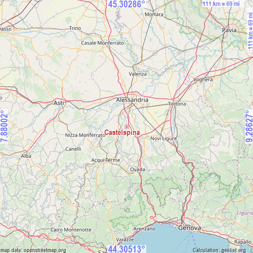
Castelspina GPS coordinates[2]
44° 48' 22.14" North, 8° 34' 59.34" East
| Map corner | latitude | longitude |
|---|---|---|
| Upper-left | 45.30286°, | 7.88002° |
| Center: | 44.80615°, | 8.58315° |
| Lower-right: | 44.30513°, | 9.28627° |
| Map W x H: | 110.9×110.9 km | = 68.9×68.9mi |
| max Lat: | 47.04031° ⇑43.7% North |
| Castelspina: | 44.80615° |
| min Lat: | ⇓56.3% South 35.50142° |
| min Long | Castelspina | max Long |
| 6.69888° | 8.58315° | 18.48682° |
| W 13.1%⇐ | ⇒86.9% E |
Elevation
Elevation of Castelspina is 115 m = 377 ft, and this is 191.7 m = 629 ft below average elevation for this country.
| Max E: |
2085 m = 6841 ft | 67.1% |
| Avg. | 306.7 m = 1006 ft | |
| Castelspina | 115 m = 377 ft | |
Min E: |
-4 m = -13 ft | 32.9% |
See also: Italy elevation on elevation.city.
Geographical zone
Castelspina is located in North temperate zone (between Tropic of Cancer and the Arctic Circle). Distance of this Northern Tropic circle is 2376.1 km =1476.4 mi to South.| Distance of | km | miles | from Castelspina |
|---|---|---|---|
| North Pole | 5025.1 | 3122.5 | to North |
| Arctic Circle | 2419.2 | 1503.2 | to North |
| Tropic Cancer | 2376.1 | 1476.4 | to South |
| Equator | 4982 | 3095.7 | to South |


Nearby cities:
15 places around Castelspina: (largest is in red/bold)
• Borgoratto Alessandrino
4.9 km =3 mi,  313°
313°
• Bosco Marengo
7.9 km =4.9 mi,  75°
75°
• Cabanette
8.5 km =5.3 mi,  357°
357°
• Cantalupo
7.2 km =4.5 mi,  340°
340°
• Carentino
9.2 km =5.7 mi,  285°
285°
• Casal Cermelli
4.6 km =2.9 mi,  45°
45°
• Cassine
7.4 km =4.6 mi,  215°
215°
• Castellazzo Bormida
4.2 km =2.6 mi, 355°
• Castelnuovo Bormida
7.5 km =4.7 mi,  199°
199°
• Frascaro
4.6 km =2.9 mi,  298°
298°
• Fresonara
8.5 km =5.3 mi,  107°
107°
• Frugarolo
8.6 km =5.3 mi,  64°
64°
• Gamalero
3.3 km =2.1 mi,  274°
274°
• Predosa
8.4 km =5.2 mi,  137°
137°
• Sezzadio
2.5 km =1.6 mi, 199°
Sources, notices
• [Note1] Compared only with cities in Italy existing in our database
• [Src1] Map data: © OpenStreetMap contributors (CC-BY-SA)
• [Src2] Other city data from geonames.org with taken over terms of usage.
• [Src3] Geographical zone / Annual Mean Temperature by Robert A. Rohde @ Wikipedia
