Moncestino geodata
Moncestino (Piedmont) is a seat of a third-order administrative division; located in Italy in Europe/Rome (GMT+2) time zone. With population of 63 people, there are 11560 cities with bigger population in this country. Compared to other cities in Italy, 63.9% of cities are located further ↓South; 91.5% of cities are located further →East and 58.1% of cities have lower elevation than Moncestino. Note1


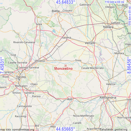
Moncestino GPS coordinates[2]
45° 9' 16.74" North, 8° 9' 41.148" East
| Map corner | latitude | longitude |
|---|---|---|
| Upper-left | 45.64833°, | 7.45831° |
| Center: | 45.15465°, | 8.16143° |
| Lower-right: | 44.65665°, | 8.86456° |
| Map W x H: | 110.3×110.3 km | = 68.5×68.5mi |
| max Lat: | 47.04031° ⇑36.1% North |
| Moncestino: | 45.15465° |
| min Lat: | ⇓63.9% South 35.50142° |
| min Long | Moncestino | max Long |
| 6.69888° | 8.16143° | 18.48682° |
| W 8.5%⇐ | ⇒91.5% E |
Elevation
Elevation of Moncestino is 286 m = 938 ft, and this is 20.7 m = 68 ft below average elevation for this country.
| Max E: |
2085 m = 6841 ft | 41.9% |
| Avg. | 306.7 m = 1006 ft | |
| Moncestino | 286 m = 938 ft | |
Min E: |
-4 m = -13 ft | 58.1% |
See also: Italy elevation on elevation.city.
Geographical zone
Moncestino is located in North temperate zone (between Tropic of Cancer and the Arctic Circle). Distance of this North polar circle is 2380.4 km =1479.1 mi to North.| Distance of | km | miles | from Moncestino |
|---|---|---|---|
| North Pole | 4986.3 | 3098.3 | to North |
| Arctic Circle | 2380.4 | 1479.1 | to North |
| Tropic Cancer | 2414.8 | 1500.5 | to South |
| Equator | 5020.7 | 3119.7 | to South |


Nearby cities:
15 places around Moncestino: (largest is in red/bold)
• Brozolo
8.2 km =5.1 mi,  239°
239°
• Brusasco
7.9 km =4.9 mi,  270°
270°
• Cerrina
5.5 km =3.4 mi,  132°
132°
• Crescentino
7.7 km =4.8 mi,  310°
310°
• Fontanetto Po
5 km =3.1 mi,  28°
28°
• Gabiano
2.6 km =1.6 mi,  83°
83°
• Mombello Monferrato
7.4 km =4.6 mi,  109°
109°
• Murisengo
8.4 km =5.2 mi,  194°
194°
• Odalengo Grande
5.1 km =3.2 mi,  174°
174°
• Palazzolo Vercellese
6.6 km =4.1 mi,  58°
58°
• Robella
7.5 km =4.7 mi,  218°
218°
• Valentino
5.3 km =3.3 mi, 271°
• Valle Cerrina
5.9 km =3.7 mi,  138°
138°
• Verrua Savoia
5.4 km =3.4 mi, 272°
• Villamiroglio
2.4 km =1.5 mi,  161°
161°
Sources, notices
• [Note1] Compared only with cities in Italy existing in our database
• [Src1] Map data: © OpenStreetMap contributors (CC-BY-SA)
• [Src2] Other city data from geonames.org with taken over terms of usage.
• [Src3] Geographical zone / Annual Mean Temperature by Robert A. Rohde @ Wikipedia
