Crescentino geodata
Crescentino (Piedmont) is a seat of a third-order administrative division; located in Italy in Europe/Rome (GMT+2) time zone. With population of 6,003 people, there are 1638 cities with bigger population in this country. Compared to other cities in Italy, 65% of cities are located further ↓South; 92.5% of cities are located further →East and 60.2% of cities have higher elevation than Crescentino. Note1


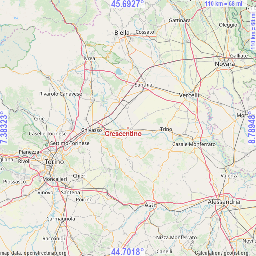
Crescentino GPS coordinates[2]
45° 11' 57.876" North, 8° 5' 10.86" East
| Map corner | latitude | longitude |
|---|---|---|
| Upper-left | 45.6927°, | 7.38323° |
| Center: | 45.19941°, | 8.08635° |
| Lower-right: | 44.7018°, | 8.78948° |
| Map W x H: | 110.2×110.2 km | = 68.5×68.5mi |
| max Lat: | 47.04031° ⇑35% North |
| Crescentino: | 45.19941° |
| min Lat: | ⇓65% South 35.50142° |
| min Long | Crescentino | max Long |
| 6.69888° | 8.08635° | 18.48682° |
| W 7.5%⇐ | ⇒92.5% E |
Elevation
Elevation of Crescentino is 162 m = 531 ft, and this is 144.7 m = 475 ft below average elevation for this country.
| Max E: |
2085 m = 6841 ft | 60.2% |
| Avg. | 306.7 m = 1006 ft | |
| Crescentino | 162 m = 531 ft | |
Min E: |
-4 m = -13 ft | 39.8% |
See also: Italy elevation on elevation.city.
Geographical zone
Crescentino is located in North temperate zone (between Tropic of Cancer and the Arctic Circle). Distance of this North polar circle is 2375.5 km =1476.1 mi to North.| Distance of | km | miles | from Crescentino |
|---|---|---|---|
| North Pole | 4981.4 | 3095.3 | to North |
| Arctic Circle | 2375.5 | 1476.1 | to North |
| Tropic Cancer | 2419.8 | 1503.6 | to South |
| Equator | 5025.7 | 3122.8 | to South |


Nearby cities:
15 places around Crescentino: (largest is in red/bold)
• Borgo Revel
5.1 km =3.2 mi,  261°
261°
• Brusasco
5.3 km =3.3 mi,  201°
201°
• Cavagnolo
6.1 km =3.8 mi,  208°
208°
• Fontanetto Po
8.3 km =5.2 mi,  93°
93°
• Lamporo
3.6 km =2.2 mi,  15°
15°
• Lauriano
8.4 km =5.2 mi,  238°
238°
• Moncestino
7.7 km =4.8 mi,  130°
130°
• Monteu da Po
7.9 km =4.9 mi,  225°
225°
• Pomaretto
6.1 km =3.8 mi, 210°
• Saluggia
7 km =4.3 mi,  306°
306°
• Sant'Antonino
6.5 km =4 mi,  333°
333°
• Torrazza Piemonte
8.8 km =5.5 mi,  281°
281°
• Valentino
4.9 km =3 mi,  173°
173°
• Verolengo
9.1 km =5.7 mi, 263°
• Verrua Savoia
4.8 km =3 mi, 174°
Sources, notices
• [Note1] Compared only with cities in Italy existing in our database
• [Src1] Map data: © OpenStreetMap contributors (CC-BY-SA)
• [Src2] Other city data from geonames.org with taken over terms of usage.
• [Src3] Geographical zone / Annual Mean Temperature by Robert A. Rohde @ Wikipedia
