Issogne geodata
Issogne (Aosta Valley) is a seat of a third-order administrative division; located in Italy in Europe/Rome (GMT+2) time zone. With population of 1,346 people, there are 5495 cities with bigger population in this country. Compared to other cities in Italy, 79.3% of cities are located further ↓South; 96.4% of cities are located further →East and 68.6% of cities have lower elevation than Issogne. Note1


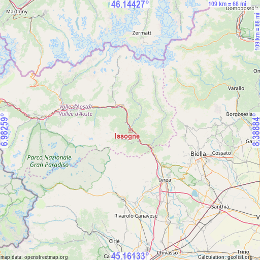
Issogne GPS coordinates[2]
45° 39' 17.856" North, 7° 41' 8.556" East
| Map corner | latitude | longitude |
|---|---|---|
| Upper-left | 46.14427°, | 6.98259° |
| Center: | 45.65496°, | 7.68571° |
| Lower-right: | 45.16133°, | 8.38884° |
| Map W x H: | 109.3×109.3 km | = 67.9×67.9mi |
| max Lat: | 47.04031° ⇑20.7% North |
| Issogne: | 45.65496° |
| min Lat: | ⇓79.3% South 35.50142° |
| min Long | Issogne | max Long |
| 6.69888° | 7.68571° | 18.48682° |
| W 3.6%⇐ | ⇒96.4% E |
Elevation
Elevation of Issogne is 380 m = 1247 ft, and this is 73.3 m = 240 ft above average elevation for this country.
| Max E: |
2085 m = 6841 ft | 31.4% |
| Issogne | 380 m 1247 ft | |
| Avg. | 306.7 m = 1006 ft | |
Min E: |
-4 m = -13 ft | 68.6% |
See also: Italy elevation on elevation.city.
Geographical zone
Issogne is located in North temperate zone (between Tropic of Cancer and the Arctic Circle). Distance of this North polar circle is 2324.8 km =1444.6 mi to North.| Distance of | km | miles | from Issogne |
|---|---|---|---|
| North Pole | 4930.7 | 3063.8 | to North |
| Arctic Circle | 2324.8 | 1444.6 | to North |
| Tropic Cancer | 2470.4 | 1535 | to South |
| Equator | 5076.4 | 3154.3 | to South |


Nearby cities:
15 places around Issogne: (largest is in red/bold)
• Arnad
2.6 km =1.6 mi,  109°
109°
• Bard
6.8 km =4.2 mi,  137°
137°
• Berriat
5.9 km =3.7 mi,  352°
352°
• Challand-Saint-Anselme
7.6 km =4.7 mi,  29°
29°
• Challand-Saint-Victor
4.2 km =2.6 mi,  20°
20°
• Champdepraz
4 km =2.5 mi,  326°
326°
• Champorcher
6.1 km =3.8 mi,  235°
235°
• Emarese
7.8 km =4.8 mi,  2°
2°
• Hone
6.2 km =3.9 mi, 138°
• La Place
0.2 km =0.1 mi,  233°
233°
• Montjovet
6 km =3.7 mi, 351°
• Pont-Bozet
5.3 km =3.3 mi,  179°
179°
• Quincod
7.7 km =4.8 mi, 29°
• Verres
1.3 km =0.8 mi,  11°
11°
• Villa-Nabian
4.1 km =2.5 mi, 20°
Sources, notices
• [Note1] Compared only with cities in Italy existing in our database
• [Src1] Map data: © OpenStreetMap contributors (CC-BY-SA)
• [Src2] Other city data from geonames.org with taken over terms of usage.
• [Src3] Geographical zone / Annual Mean Temperature by Robert A. Rohde @ Wikipedia
