Entratico geodata
Entratico (Lombardy) is a seat of a third-order administrative division; located in Italy in Europe/Rome (GMT+2) time zone. With population of 1,734 people, there are 4600 cities with bigger population in this country. Compared to other cities in Italy, 81.6% of cities are located further ↓South; 69.1% of cities are located further →East and 56.2% of cities have lower elevation than Entratico. Note1


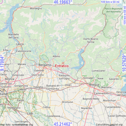
Entratico GPS coordinates[2]
45° 42' 28.008" North, 9° 52' 23.376" East
| Map corner | latitude | longitude |
|---|---|---|
| Upper-left | 46.19663°, | 9.17004° |
| Center: | 45.70778°, | 9.87316° |
| Lower-right: | 45.21462°, | 10.57629° |
| Map W x H: | 109.2×109.2 km | = 67.9×67.9mi |
| max Lat: | 47.04031° ⇑18.4% North |
| Entratico: | 45.70778° |
| min Lat: | ⇓81.6% South 35.50142° |
| min Long | Entratico | max Long |
| 6.69888° | 9.87316° | 18.48682° |
| W 30.9%⇐ | ⇒69.1% E |
Elevation
Elevation of Entratico is 273 m = 896 ft, and this is 33.7 m = 111 ft below average elevation for this country.
| Max E: |
2085 m = 6841 ft | 43.8% |
| Avg. | 306.7 m = 1006 ft | |
| Entratico | 273 m = 896 ft | |
Min E: |
-4 m = -13 ft | 56.2% |
See also: Italy elevation on elevation.city.
Geographical zone
Entratico is located in North temperate zone (between Tropic of Cancer and the Arctic Circle). Distance of this North polar circle is 2318.9 km =1440.9 mi to North.| Distance of | km | miles | from Entratico |
|---|---|---|---|
| North Pole | 4924.8 | 3060.1 | to North |
| Arctic Circle | 2318.9 | 1440.9 | to North |
| Tropic Cancer | 2476.3 | 1538.7 | to South |
| Equator | 5082.2 | 3157.9 | to South |


Nearby cities:
15 places around Entratico: (largest is in red/bold)
• Abbazia
5.1 km =3.2 mi,  331°
331°
• Berzo San Fermo
2.7 km =1.7 mi,  61°
61°
• Borgo di Terzo
2 km =1.2 mi,  43°
43°
• Casazza
5.2 km =3.2 mi,  29°
29°
• Casco
3.8 km =2.4 mi,  275°
275°
• Celatica-Tolari
5.3 km =3.3 mi,  154°
154°
• Cenate Sopra
4 km =2.5 mi, 278°
• Cenate di Sotto
3.8 km =2.4 mi,  254°
254°
• Chiesa
3.7 km =2.3 mi,  122°
122°
• Foresto Sparso
4.1 km =2.5 mi, 117°
• Grone
3.5 km =2.2 mi,  52°
52°
• Luzzana
1 km =0.6 mi, 36°
• Trescore Balneario
2.9 km =1.8 mi,  238°
238°
• Vigano San Martino
2.7 km =1.7 mi, 41°
• Zandobbio
2.7 km =1.7 mi,  206°
206°
Sources, notices
• [Note1] Compared only with cities in Italy existing in our database
• [Src1] Map data: © OpenStreetMap contributors (CC-BY-SA)
• [Src2] Other city data from geonames.org with taken over terms of usage.
• [Src3] Geographical zone / Annual Mean Temperature by Robert A. Rohde @ Wikipedia
