Trescore Balneario geodata
Trescore Balneario (Lombardy) is a seat of a third-order administrative division; located in Italy in Europe/Rome (GMT+2) time zone. With population of 8,479 people, there are 1126 cities with bigger population in this country. Compared to other cities in Italy, 80.9% of cities are located further ↓South; 69.4% of cities are located further →East and 55.9% of cities have lower elevation than Trescore Balneario. Note1
Administrative division(s):
- Level 1: Lombardy
- Level 2: Provincia di Bergamo
- Level 3: Trescore Balneario


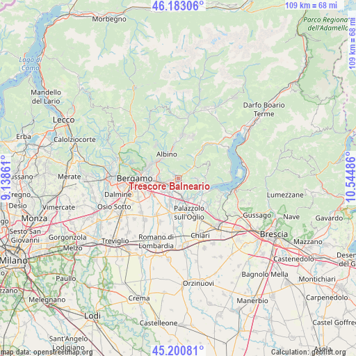
Trescore Balneario GPS coordinates[2]
45° 41' 38.724" North, 9° 50' 30.228" East
| Map corner | latitude | longitude |
|---|---|---|
| Upper-left | 46.18306°, | 9.13861° |
| Center: | 45.69409°, | 9.84173° |
| Lower-right: | 45.20081°, | 10.54486° |
| Map W x H: | 109.2×109.2 km | = 67.9×67.9mi |
| max Lat: | 47.04031° ⇑19.1% North |
| Trescore Balneario: | 45.69409° |
| min Lat: | ⇓80.9% South 35.50142° |
| min Long | Trescore Balnea | max Long |
| 6.69888° | 9.84173° | 18.48682° |
| W 30.6%⇐ | ⇒69.4% E |
Elevation
Elevation of Trescore Balneario is 271 m = 889 ft, and this is 35.7 m = 117 ft below average elevation for this country.
| Max E: |
2085 m = 6841 ft | 44.1% |
| Avg. | 306.7 m = 1006 ft | |
| Trescore Balneario | 271 m = 889 ft | |
Min E: |
-4 m = -13 ft | 55.9% |
See also: Italy elevation on elevation.city.
Geographical zone
Trescore Balneario is located in North temperate zone (between Tropic of Cancer and the Arctic Circle). Distance of this North polar circle is 2320.5 km =1441.9 mi to North.| Distance of | km | miles | from Trescore Balneario |
|---|---|---|---|
| North Pole | 4926.4 | 3061.1 | to North |
| Arctic Circle | 2320.5 | 1441.9 | to North |
| Tropic Cancer | 2474.8 | 1537.8 | to South |
| Equator | 5080.7 | 3157 | to South |


Nearby cities:
15 places around Trescore Balneario: (largest is in red/bold)
• Borgo di Terzo
4.8 km =3 mi,  52°
52°
• Carobbio
3.4 km =2.1 mi,  195°
195°
• Carobbio degli Angeli
3.4 km =2.1 mi, 196°
• Casco
2.3 km =1.4 mi,  324°
324°
• Cenate Sopra
2.6 km =1.6 mi, 324°
• Cenate di Sotto
1.3 km =0.8 mi,  294°
294°
• Chiuduno
4.9 km =3 mi,  172°
172°
• Costa di Mezzate
5 km =3.1 mi,  225°
225°
• Entratico
2.9 km =1.8 mi,  58°
58°
• Gandosso
5.4 km =3.4 mi,  136°
136°
• Gorlago
2.7 km =1.7 mi,  213°
213°
• Luzzana
3.9 km =2.4 mi, 52°
• Montello
3.7 km =2.3 mi, 228°
• San Paolo d'Argon
3.1 km =1.9 mi,  258°
258°
• Zandobbio
1.5 km =0.9 mi,  125°
125°
Sources, notices
• [Note1] Compared only with cities in Italy existing in our database
• [Src1] Map data: © OpenStreetMap contributors (CC-BY-SA)
• [Src2] Other city data from geonames.org with taken over terms of usage.
• [Src3] Geographical zone / Annual Mean Temperature by Robert A. Rohde @ Wikipedia
