Borgo San Siro geodata
Borgo San Siro (Lombardy) is a seat of a third-order administrative division; located in Italy in Europe/Rome (GMT+2) time zone. With population of 714 people, there are 8195 cities with bigger population in this country. Compared to other cities in Italy, 65.8% of cities are located further ↓South; 82.5% of cities are located further →East and 69.7% of cities have higher elevation than Borgo San Siro. Note1


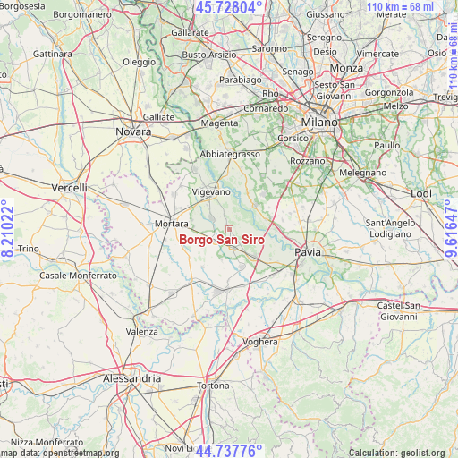
Borgo San Siro GPS coordinates[2]
45° 14' 6.216" North, 8° 54' 48.024" East
| Map corner | latitude | longitude |
|---|---|---|
| Upper-left | 45.72804°, | 8.21022° |
| Center: | 45.23506°, | 8.91334° |
| Lower-right: | 44.73776°, | 9.61647° |
| Map W x H: | 110.1×110.1 km | = 68.4×68.4mi |
| max Lat: | 47.04031° ⇑34.2% North |
| Borgo San Siro: | 45.23506° |
| min Lat: | ⇓65.8% South 35.50142° |
| min Long | Borgo San Siro | max Long |
| 6.69888° | 8.91334° | 18.48682° |
| W 17.5%⇐ | ⇒82.5% E |
Elevation
Elevation of Borgo San Siro is 99 m = 325 ft, and this is 207.7 m = 681 ft below average elevation for this country.
| Max E: |
2085 m = 6841 ft | 69.7% |
| Avg. | 306.7 m = 1006 ft | |
| Borgo San Siro | 99 m = 325 ft | |
Min E: |
-4 m = -13 ft | 30.3% |
See also: Italy elevation on elevation.city.
Geographical zone
Borgo San Siro is located in North temperate zone (between Tropic of Cancer and the Arctic Circle). Distance of this North polar circle is 2371.5 km =1473.6 mi to North.| Distance of | km | miles | from Borgo San Siro |
|---|---|---|---|
| North Pole | 4977.4 | 3092.8 | to North |
| Arctic Circle | 2371.5 | 1473.6 | to North |
| Tropic Cancer | 2423.7 | 1506 | to South |
| Equator | 5029.7 | 3125.3 | to South |


Nearby cities:
15 places around Borgo San Siro: (largest is in red/bold)
• Alagna
7.6 km =4.7 mi,  194°
194°
• Bereguardo
9.3 km =5.8 mi,  74°
74°
• Besate
9.7 km =6 mi,  26°
26°
• Dorno
9.5 km =5.9 mi,  162°
162°
• Gambolò
5.3 km =3.3 mi,  304°
304°
• Garlasco
4.5 km =2.8 mi,  170°
170°
• Gropello Cairoli
9 km =5.6 mi,  135°
135°
• Motta Visconti
8.5 km =5.3 mi,  46°
46°
• Remondò
8.6 km =5.3 mi,  273°
273°
• Trivolzio
10.5 km =6.5 mi,  75°
75°
• Tromello
4.4 km =2.7 mi,  229°
229°
• Trovo
10.9 km =6.8 mi,  60°
60°
• Valeggio
10.2 km =6.3 mi,  203°
203°
• Vigevano
9.9 km =6.2 mi,  332°
332°
• Zerbolò
8.5 km =5.3 mi,  111°
111°
Sources, notices
• [Note1] Compared only with cities in Italy existing in our database
• [Src1] Map data: © OpenStreetMap contributors (CC-BY-SA)
• [Src2] Other city data from geonames.org with taken over terms of usage.
• [Src3] Geographical zone / Annual Mean Temperature by Robert A. Rohde @ Wikipedia
