Alagna geodata
Alagna (Lombardy) is a seat of a third-order administrative division; located in Italy in Europe/Rome (GMT+2) time zone. With population of 843 people, there are 7431 cities with bigger population in this country. Compared to other cities in Italy, 64.3% of cities are located further ↓South; 82.9% of cities are located further →East and 70.9% of cities have higher elevation than Alagna. Note1


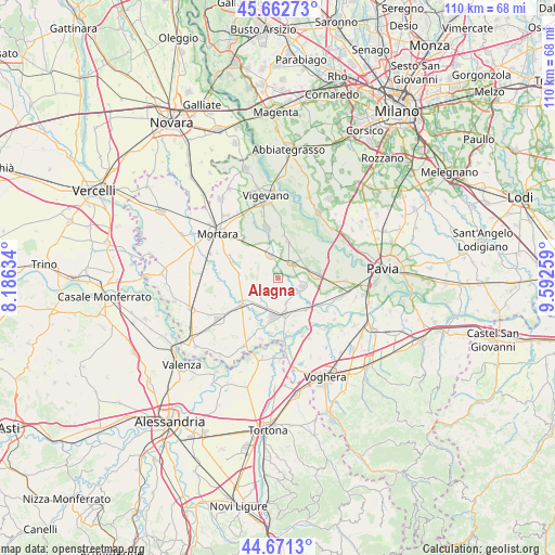
Alagna GPS coordinates[2]
45° 10' 9.012" North, 8° 53' 22.092" East
| Map corner | latitude | longitude |
|---|---|---|
| Upper-left | 45.66273°, | 8.18634° |
| Center: | 45.16917°, | 8.88947° |
| Lower-right: | 44.6713°, | 9.59259° |
| Map W x H: | 110.2×110.2 km | = 68.5×68.5mi |
| max Lat: | 47.04031° ⇑35.7% North |
| Alagna: | 45.16917° |
| min Lat: | ⇓64.3% South 35.50142° |
| min Long | Alagna | max Long |
| 6.69888° | 8.88947° | 18.48682° |
| W 17.1%⇐ | ⇒82.9% E |
Elevation
Elevation of Alagna is 93 m = 305 ft, and this is 213.7 m = 701 ft below average elevation for this country.
| Max E: |
2085 m = 6841 ft | 70.9% |
| Avg. | 306.7 m = 1006 ft | |
| Alagna | 93 m = 305 ft | |
Min E: |
-4 m = -13 ft | 29.1% |
See also: Italy elevation on elevation.city.
Geographical zone
Alagna is located in North temperate zone (between Tropic of Cancer and the Arctic Circle). Distance of this North polar circle is 2378.8 km =1478.1 mi to North.| Distance of | km | miles | from Alagna |
|---|---|---|---|
| North Pole | 4984.7 | 3097.3 | to North |
| Arctic Circle | 2378.8 | 1478.1 | to North |
| Tropic Cancer | 2416.4 | 1501.5 | to South |
| Equator | 5022.3 | 3120.7 | to South |


Nearby cities:
15 places around Alagna: (largest is in red/bold)
• Borgo San Siro
7.6 km =4.7 mi,  14°
14°
• Cergnago
9.8 km =6.1 mi,  289°
289°
• Dorno
5.1 km =3.2 mi,  109°
109°
• Ferrera Erbognone
6.4 km =4 mi,  197°
197°
• Galliavola
9.7 km =6 mi,  214°
214°
• Garlasco
3.9 km =2.4 mi,  42°
42°
• Gropello Cairoli
8.2 km =5.1 mi,  83°
83°
• Lomello
9.1 km =5.7 mi,  233°
233°
• Ottobiano
4.8 km =3 mi,  249°
249°
• Pieve Albignola
8.3 km =5.2 mi,  138°
138°
• San Giorgio di Lomellina
7.8 km =4.8 mi,  274°
274°
• Sannazzaro de' Burgondi
7.6 km =4.7 mi,  169°
169°
• Scaldasole
5.2 km =3.2 mi,  161°
161°
• Tromello
4.7 km =2.9 mi,  341°
341°
• Valeggio
3 km =1.9 mi, 226°
Sources, notices
• [Note1] Compared only with cities in Italy existing in our database
• [Src1] Map data: © OpenStreetMap contributors (CC-BY-SA)
• [Src2] Other city data from geonames.org with taken over terms of usage.
• [Src3] Geographical zone / Annual Mean Temperature by Robert A. Rohde @ Wikipedia
