Gambolò geodata
Gambolò (Lombardy) is a seat of a third-order administrative division; located in Italy in Europe/Rome (GMT+2) time zone. With population of 7,939 people, there are 1228 cities with bigger population in this country. Compared to other cities in Italy, 66.5% of cities are located further ↓South; 83.4% of cities are located further →East and 68.8% of cities have higher elevation than Gambolò. Note1


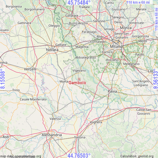
Gambolò GPS coordinates[2]
45° 15' 43.524" North, 8° 51' 29.52" East
| Map corner | latitude | longitude |
|---|---|---|
| Upper-left | 45.75484°, | 8.15508° |
| Center: | 45.26209°, | 8.8582° |
| Lower-right: | 44.76503°, | 9.56133° |
| Map W x H: | 110.1×110.1 km | = 68.4×68.4mi |
| max Lat: | 47.04031° ⇑33.5% North |
| Gambolò: | 45.26209° |
| min Lat: | ⇓66.5% South 35.50142° |
| min Long | Gambolò | max Long |
| 6.69888° | 8.8582° | 18.48682° |
| W 16.6%⇐ | ⇒83.4% E |
Elevation
Elevation of Gambolò is 104 m = 341 ft, and this is 202.7 m = 665 ft below average elevation for this country.
| Max E: |
2085 m = 6841 ft | 68.8% |
| Avg. | 306.7 m = 1006 ft | |
| Gambolò | 104 m = 341 ft | |
Min E: |
-4 m = -13 ft | 31.2% |
See also: Italy elevation on elevation.city.
Geographical zone
Gambolò is located in North temperate zone (between Tropic of Cancer and the Arctic Circle). Distance of this North polar circle is 2368.5 km =1471.7 mi to North.| Distance of | km | miles | from Gambolò |
|---|---|---|---|
| North Pole | 4974.4 | 3090.9 | to North |
| Arctic Circle | 2368.5 | 1471.7 | to North |
| Tropic Cancer | 2426.8 | 1507.9 | to South |
| Equator | 5032.7 | 3127.2 | to South |


Nearby cities:
15 places around Gambolò: (largest is in red/bold)
• Alagna
10.6 km =6.6 mi,  166°
166°
• Besate
10.4 km =6.5 mi,  57°
57°
• Borgo San Siro
5.3 km =3.3 mi,  124°
124°
• Cassolnovo
11.6 km =7.2 mi,  341°
341°
• Cergnago
9.8 km =6.1 mi,  223°
223°
• Cilavegna
10.4 km =6.5 mi,  301°
301°
• Garlasco
9 km =5.6 mi,  145°
145°
• Gravellona
10.4 km =6.5 mi,  314°
314°
• Mortara
9.9 km =6.2 mi,  261°
261°
• Motta Visconti
10.9 km =6.8 mi,  74°
74°
• Parona
8.7 km =5.4 mi,  284°
284°
• Remondò
4.9 km =3 mi,  239°
239°
• San Giorgio di Lomellina
11.1 km =6.9 mi,  208°
208°
• Tromello
6 km =3.7 mi, 170°
• Vigevano
5.8 km =3.6 mi,  357°
357°
Sources, notices
• [Note1] Compared only with cities in Italy existing in our database
• [Src1] Map data: © OpenStreetMap contributors (CC-BY-SA)
• [Src2] Other city data from geonames.org with taken over terms of usage.
• [Src3] Geographical zone / Annual Mean Temperature by Robert A. Rohde @ Wikipedia
