Buguggiate geodata
Buguggiate (Lombardy) is a seat of a third-order administrative division; located in Italy in Europe/Rome (GMT+2) time zone. With population of 3,092 people, there are 2970 cities with bigger population in this country. Compared to other cities in Italy, 85% of cities are located further ↓South; 84% of cities are located further →East and 62.1% of cities have lower elevation than Buguggiate. Note1


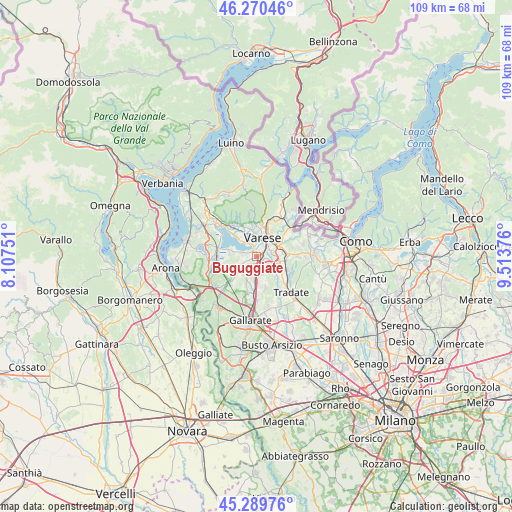
Buguggiate GPS coordinates[2]
45° 46' 56.172" North, 8° 48' 38.268" East
| Map corner | latitude | longitude |
|---|---|---|
| Upper-left | 46.27046°, | 8.10751° |
| Center: | 45.78227°, | 8.81063° |
| Lower-right: | 45.28976°, | 9.51376° |
| Map W x H: | 109×109 km | = 67.7×67.7mi |
| max Lat: | 47.04031° ⇑15% North |
| Buguggiate: | 45.78227° |
| min Lat: | ⇓85% South 35.50142° |
| min Long | Buguggiate | max Long |
| 6.69888° | 8.81063° | 18.48682° |
| W 16%⇐ | ⇒84% E |
Elevation
Elevation of Buguggiate is 316 m = 1037 ft, and this is 9.3 m = 31 ft above average elevation for this country.
| Max E: |
2085 m = 6841 ft | 37.9% |
| Buguggiate | 316 m 1037 ft | |
| Avg. | 306.7 m = 1006 ft | |
Min E: |
-4 m = -13 ft | 62.1% |
See also: Italy elevation on elevation.city.
Geographical zone
Buguggiate is located in North temperate zone (between Tropic of Cancer and the Arctic Circle). Distance of this North polar circle is 2310.7 km =1435.8 mi to North.| Distance of | km | miles | from Buguggiate |
|---|---|---|---|
| North Pole | 4916.6 | 3055 | to North |
| Arctic Circle | 2310.7 | 1435.8 | to North |
| Tropic Cancer | 2484.6 | 1543.9 | to South |
| Equator | 5090.5 | 3163.1 | to South |


Nearby cities:
15 places around Buguggiate: (largest is in red/bold)
• Azzate
1.4 km =0.9 mi,  249°
249°
• Bodio
4.7 km =2.9 mi,  280°
280°
• Bodio Lomnago
4.7 km =2.9 mi, 278°
• Brunello
2.3 km =1.4 mi,  211°
211°
• Capolago
1.3 km =0.8 mi,  357°
357°
• Cascine Maggio
2.5 km =1.6 mi,  178°
178°
• Castronno
3.8 km =2.4 mi, 175°
• Crosio della Valle
4 km =2.5 mi,  231°
231°
• Daverio
2.9 km =1.8 mi,  260°
260°
• Galliate Lombardo
3.1 km =1.9 mi, 275°
• Gazzada Schianno
1.8 km =1.1 mi,  97°
97°
• Lozza
3.7 km =2.3 mi, 101°
• Montonate
4.9 km =3 mi,  216°
216°
• Morazzone
2.4 km =1.5 mi,  145°
145°
• Varese
4.4 km =2.7 mi,  14°
14°
Sources, notices
• [Note1] Compared only with cities in Italy existing in our database
• [Src1] Map data: © OpenStreetMap contributors (CC-BY-SA)
• [Src2] Other city data from geonames.org with taken over terms of usage.
• [Src3] Geographical zone / Annual Mean Temperature by Robert A. Rohde @ Wikipedia
