Varese geodata
Varese (Lombardy) is a seat of a second-order administrative division; located in Italy in Europe/Rome (GMT+2) time zone. With population of 76,851 people, there are 62 cities with bigger population in this country. Compared to other cities in Italy, 86.7% of cities are located further ↓South; 83.8% of cities are located further →East and 69.4% of cities have lower elevation than Varese. Note1


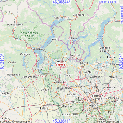
Varese GPS coordinates[2]
45° 49' 14.088" North, 8° 49' 30.396" East
| Map corner | latitude | longitude |
|---|---|---|
| Upper-left | 46.30844°, | 8.12199° |
| Center: | 45.82058°, | 8.82511° |
| Lower-right: | 45.32841°, | 9.52824° |
| Map W x H: | 109×109 km | = 67.7×67.7mi |
| max Lat: | 47.04031° ⇑13.3% North |
| Varese: | 45.82058° |
| min Lat: | ⇓86.7% South 35.50142° |
| min Long | Varese | max Long |
| 6.69888° | 8.82511° | 18.48682° |
| W 16.2%⇐ | ⇒83.8% E |
Elevation
Elevation of Varese is 389 m = 1276 ft, and this is 82.3 m = 270 ft above average elevation for this country.
| Max E: |
2085 m = 6841 ft | 30.6% |
| Varese | 389 m 1276 ft | |
| Avg. | 306.7 m = 1006 ft | |
Min E: |
-4 m = -13 ft | 69.4% |
See also: Varese elevation on elevation.city.
Geographical zone
Varese is located in North temperate zone (between Tropic of Cancer and the Arctic Circle). Distance of this North polar circle is 2306.4 km =1433.1 mi to North.| Distance of | km | miles | from Varese |
|---|---|---|---|
| North Pole | 4912.3 | 3052.4 | to North |
| Arctic Circle | 2306.4 | 1433.1 | to North |
| Tropic Cancer | 2488.9 | 1546.5 | to South |
| Equator | 5094.8 | 3165.8 | to South |


Nearby cities:
15 places around Varese: (largest is in red/bold)
• Arcisate
5.1 km =3.2 mi,  40°
40°
• Azzate
5.3 km =3.3 mi,  206°
206°
• Barasso
5.7 km =3.5 mi,  292°
292°
• Brenno Useria
6.1 km =3.8 mi, 42°
• Buguggiate
4.4 km =2.7 mi,  194°
194°
• Calcinate del Pesce
4.8 km =3 mi,  263°
263°
• Cantello
5.5 km =3.4 mi,  87°
87°
• Capolago
3.2 km =2 mi,  201°
201°
• Casciago
3.5 km =2.2 mi, 292°
• Galliate Lombardo
5.8 km =3.6 mi,  226°
226°
• Gazzada Schianno
4.5 km =2.8 mi,  171°
171°
• Induno Olona
3 km =1.9 mi,  23°
23°
• Lozza
5.6 km =3.5 mi,  153°
153°
• Luvinate
4.6 km =2.9 mi,  297°
297°
• Malnate
5.3 km =3.3 mi,  124°
124°
Sources, notices
• [Note1] Compared only with cities in Italy existing in our database
• [Src1] Map data: © OpenStreetMap contributors (CC-BY-SA)
• [Src2] Other city data from geonames.org with taken over terms of usage.
• [Src3] Geographical zone / Annual Mean Temperature by Robert A. Rohde @ Wikipedia
