Inarzo geodata
Inarzo (Lombardy) is a seat of a third-order administrative division; located in Italy in Europe/Rome (GMT+2) time zone. With population of 1,038 people, there are 6514 cities with bigger population in this country. Compared to other cities in Italy, 85.2% of cities are located further ↓South; 85% of cities are located further →East and 54.4% of cities have lower elevation than Inarzo. Note1


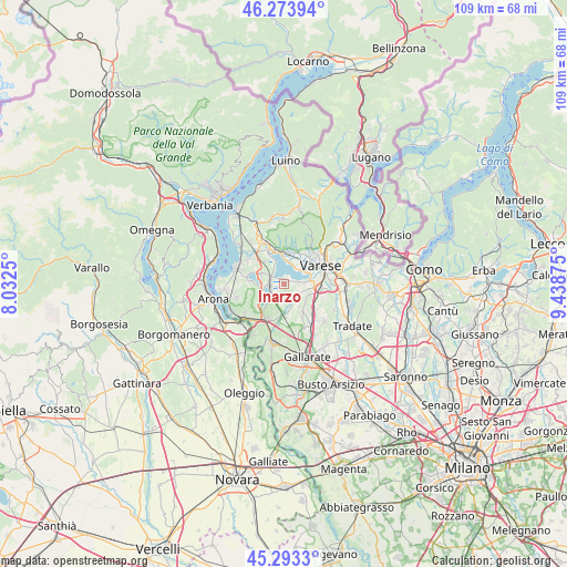
Inarzo GPS coordinates[2]
45° 47' 8.808" North, 8° 44' 8.268" East
| Map corner | latitude | longitude |
|---|---|---|
| Upper-left | 46.27394°, | 8.0325° |
| Center: | 45.78578°, | 8.73563° |
| Lower-right: | 45.2933°, | 9.43875° |
| Map W x H: | 109×109 km | = 67.7×67.7mi |
| max Lat: | 47.04031° ⇑14.8% North |
| Inarzo: | 45.78578° |
| min Lat: | ⇓85.2% South 35.50142° |
| min Long | Inarzo | max Long |
| 6.69888° | 8.73563° | 18.48682° |
| W 15%⇐ | ⇒85% E |
Elevation
Elevation of Inarzo is 262 m = 860 ft, and this is 44.7 m = 147 ft below average elevation for this country.
| Max E: |
2085 m = 6841 ft | 45.6% |
| Avg. | 306.7 m = 1006 ft | |
| Inarzo | 262 m = 860 ft | |
Min E: |
-4 m = -13 ft | 54.4% |
See also: Italy elevation on elevation.city.
Geographical zone
Inarzo is located in North temperate zone (between Tropic of Cancer and the Arctic Circle). Distance of this North polar circle is 2310.3 km =1435.6 mi to North.| Distance of | km | miles | from Inarzo |
|---|---|---|---|
| North Pole | 4916.2 | 3054.8 | to North |
| Arctic Circle | 2310.3 | 1435.6 | to North |
| Tropic Cancer | 2485 | 1544.1 | to South |
| Equator | 5090.9 | 3163.3 | to South |


Nearby cities:
15 places around Inarzo: (largest is in red/bold)
• Azzate
4.6 km =2.9 mi,  100°
100°
• Biandronno
3.7 km =2.3 mi,  325°
325°
• Bodio
1.3 km =0.8 mi,  69°
69°
• Bodio Lomnago
1.2 km =0.7 mi, 74°
• Calcinate del Pesce
3.9 km =2.4 mi,  32°
32°
• Casale Litta
2 km =1.2 mi,  167°
167°
• Cazzago Brabbia
1.1 km =0.7 mi,  356°
356°
• Comabbio
4.6 km =2.9 mi,  253°
253°
• Crosio della Valle
3.9 km =2.4 mi,  136°
136°
• Daverio
3.1 km =1.9 mi,  106°
106°
• Galliate Lombardo
2.7 km =1.7 mi,  92°
92°
• Mornago
4.7 km =2.9 mi, 165°
• Ternate
2.8 km =1.7 mi,  272°
272°
• Varano Borghi
2.8 km =1.7 mi,  242°
242°
• Villadosia
4.1 km =2.5 mi,  188°
188°
Sources, notices
• [Note1] Compared only with cities in Italy existing in our database
• [Src1] Map data: © OpenStreetMap contributors (CC-BY-SA)
• [Src2] Other city data from geonames.org with taken over terms of usage.
• [Src3] Geographical zone / Annual Mean Temperature by Robert A. Rohde @ Wikipedia
