Comabbio geodata
Comabbio (Lombardy) is a seat of a third-order administrative division; located in Italy in Europe/Rome (GMT+2) time zone. With population of 1,102 people, there are 6286 cities with bigger population in this country. Compared to other cities in Italy, 84.6% of cities are located further ↓South; 85.7% of cities are located further →East and 56% of cities have lower elevation than Comabbio. Note1


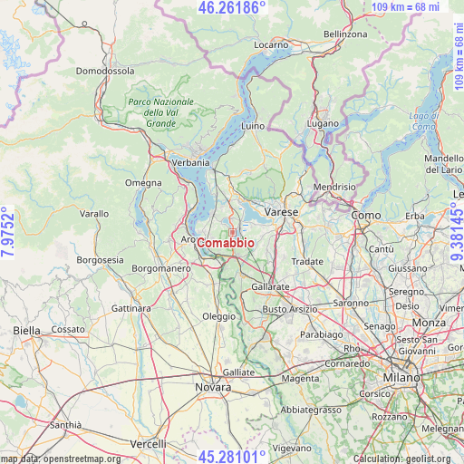
Comabbio GPS coordinates[2]
45° 46' 24.924" North, 8° 40' 41.988" East
| Map corner | latitude | longitude |
|---|---|---|
| Upper-left | 46.26186°, | 7.9752° |
| Center: | 45.77359°, | 8.67833° |
| Lower-right: | 45.28101°, | 9.38145° |
| Map W x H: | 109.1×109.1 km | = 67.8×67.8mi |
| max Lat: | 47.04031° ⇑15.4% North |
| Comabbio: | 45.77359° |
| min Lat: | ⇓84.6% South 35.50142° |
| min Long | Comabbio | max Long |
| 6.69888° | 8.67833° | 18.48682° |
| W 14.3%⇐ | ⇒85.7% E |
Elevation
Elevation of Comabbio is 272 m = 892 ft, and this is 34.7 m = 114 ft below average elevation for this country.
| Max E: |
2085 m = 6841 ft | 44% |
| Avg. | 306.7 m = 1006 ft | |
| Comabbio | 272 m = 892 ft | |
Min E: |
-4 m = -13 ft | 56% |
See also: Italy elevation on elevation.city.
Geographical zone
Comabbio is located in North temperate zone (between Tropic of Cancer and the Arctic Circle). Distance of this North polar circle is 2311.6 km =1436.4 mi to North.| Distance of | km | miles | from Comabbio |
|---|---|---|---|
| North Pole | 4917.5 | 3055.6 | to North |
| Arctic Circle | 2311.6 | 1436.4 | to North |
| Tropic Cancer | 2483.6 | 1543.2 | to South |
| Equator | 5089.5 | 3162.5 | to South |


Nearby cities:
15 places around Comabbio: (largest is in red/bold)
• Biandronno
5 km =3.1 mi,  28°
28°
• Bregano
5.8 km =3.6 mi,  7°
7°
• Cadrezzate
3.9 km =2.4 mi,  316°
316°
• Casale Litta
4.9 km =3 mi,  97°
97°
• Cazzago Brabbia
5 km =3.1 mi,  60°
60°
• Cimbro
5.3 km =3.3 mi,  142°
142°
• Corgeno
3.2 km =2 mi,  166°
166°
• Inarzo
4.6 km =2.9 mi,  73°
73°
• Mercallo
2.9 km =1.8 mi,  192°
192°
• Osmate
2.5 km =1.6 mi,  313°
313°
• Taino
4.9 km =3 mi,  255°
255°
• Ternate
2.2 km =1.4 mi,  48°
48°
• Travedona Monate
3.5 km =2.2 mi,  351°
351°
• Varano Borghi
2 km =1.2 mi,  88°
88°
• Villadosia
4.7 km =2.9 mi,  124°
124°
Sources, notices
• [Note1] Compared only with cities in Italy existing in our database
• [Src1] Map data: © OpenStreetMap contributors (CC-BY-SA)
• [Src2] Other city data from geonames.org with taken over terms of usage.
• [Src3] Geographical zone / Annual Mean Temperature by Robert A. Rohde @ Wikipedia
