Credaro geodata
Credaro (Lombardy) is a seat of a third-order administrative division; located in Italy in Europe/Rome (GMT+2) time zone. With population of 2,250 people, there are 3814 cities with bigger population in this country. Compared to other cities in Italy, 79.5% of cities are located further ↓South; 68.5% of cities are located further →East and 50.4% of cities have higher elevation than Credaro. Note1


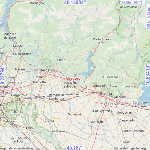
Credaro GPS coordinates[2]
45° 39' 38.088" North, 9° 55' 51.816" East
| Map corner | latitude | longitude |
|---|---|---|
| Upper-left | 46.14984°, | 9.22794° |
| Center: | 45.66058°, | 9.93106° |
| Lower-right: | 45.167°, | 10.63419° |
| Map W x H: | 109.3×109.3 km | = 67.9×67.9mi |
| max Lat: | 47.04031° ⇑20.5% North |
| Credaro: | 45.66058° |
| min Lat: | ⇓79.5% South 35.50142° |
| min Long | Credaro | max Long |
| 6.69888° | 9.93106° | 18.48682° |
| W 31.5%⇐ | ⇒68.5% E |
Elevation
Elevation of Credaro is 232 m = 761 ft, and this is 74.7 m = 245 ft below average elevation for this country.
| Max E: |
2085 m = 6841 ft | 50.4% |
| Avg. | 306.7 m = 1006 ft | |
| Credaro | 232 m = 761 ft | |
Min E: |
-4 m = -13 ft | 49.6% |
See also: Italy elevation on elevation.city.
Geographical zone
Credaro is located in North temperate zone (between Tropic of Cancer and the Arctic Circle). Distance of this North polar circle is 2324.2 km =1444.2 mi to North.| Distance of | km | miles | from Credaro |
|---|---|---|---|
| North Pole | 4930.1 | 3063.4 | to North |
| Arctic Circle | 2324.2 | 1444.2 | to North |
| Tropic Cancer | 2471.1 | 1535.5 | to South |
| Equator | 5077 | 3154.7 | to South |


Nearby cities:
15 places around Credaro: (largest is in red/bold)
• Adrara San Martino
4.8 km =3 mi,  16°
16°
• Adro
5 km =3.1 mi,  151°
151°
• Capriolo
3 km =1.9 mi,  178°
178°
• Celatica-Tolari
2.3 km =1.4 mi,  282°
282°
• Chiesa
3.6 km =2.2 mi,  336°
336°
• Clusane
5.4 km =3.4 mi,  87°
87°
• Colombaro-Timoline
5.2 km =3.2 mi,  110°
110°
• Foresto Sparso
3.5 km =2.2 mi,  345°
345°
• Gandosso
3.3 km =2.1 mi,  266°
266°
• Grumello del Monte
5.2 km =3.2 mi,  237°
237°
• Paratico
2.1 km =1.3 mi,  95°
95°
• Sarnico
2.6 km =1.6 mi,  63°
63°
• Tagliuno
2.7 km =1.7 mi,  220°
220°
• Viadanica
3.6 km =2.2 mi,  41°
41°
• Villongo
1 km =0.6 mi,  358°
358°
Sources, notices
• [Note1] Compared only with cities in Italy existing in our database
• [Src1] Map data: © OpenStreetMap contributors (CC-BY-SA)
• [Src2] Other city data from geonames.org with taken over terms of usage.
• [Src3] Geographical zone / Annual Mean Temperature by Robert A. Rohde @ Wikipedia
