Clusane geodata
Clusane (Lombardy) is a populated place; located in Italy in Europe/Rome (GMT+2) time zone. With population of 2,196 people, there are 3877 cities with bigger population in this country. Compared to other cities in Italy, 79.6% of cities are located further ↓South; 67.8% of cities are located further →East and 56.4% of cities have higher elevation than Clusane. Note1


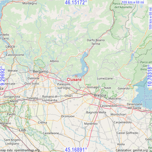
Clusane GPS coordinates[2]
45° 39' 44.892" North, 10° 0' 0.18" East
| Map corner | latitude | longitude |
|---|---|---|
| Upper-left | 46.15172°, | 9.29692° |
| Center: | 45.66247°, | 10.00005° |
| Lower-right: | 45.16891°, | 10.70318° |
| Map W x H: | 109.3×109.3 km | = 67.9×67.9mi |
| max Lat: | 47.04031° ⇑20.4% North |
| Clusane: | 45.66247° |
| min Lat: | ⇓79.6% South 35.50142° |
| min Long | Clusane | max Long |
| 6.69888° | 10.00005° | 18.48682° |
| W 32.2%⇐ | ⇒67.8% E |
Elevation
Elevation of Clusane is 192 m = 630 ft, and this is 114.7 m = 376 ft below average elevation for this country.
| Max E: |
2085 m = 6841 ft | 56.4% |
| Avg. | 306.7 m = 1006 ft | |
| Clusane | 192 m = 630 ft | |
Min E: |
-4 m = -13 ft | 43.6% |
See also: Italy elevation on elevation.city.
Geographical zone
Clusane is located in North temperate zone (between Tropic of Cancer and the Arctic Circle). Distance of this North polar circle is 2324 km =1444.1 mi to North.| Distance of | km | miles | from Clusane |
|---|---|---|---|
| North Pole | 4929.9 | 3063.3 | to North |
| Arctic Circle | 2324 | 1444.1 | to North |
| Tropic Cancer | 2471.3 | 1535.6 | to South |
| Equator | 5077.2 | 3154.8 | to South |


Nearby cities:
15 places around Clusane: (largest is in red/bold)
• Adro
5.5 km =3.4 mi,  212°
212°
• Borgonato
4.9 km =3 mi,  163°
163°
• Colombaro-Timoline
2.1 km =1.3 mi,  192°
192°
• Corte Franca
3.7 km =2.3 mi, 194°
• Credaro
5.4 km =3.4 mi,  267°
267°
• Cremignane
2 km =1.2 mi,  135°
135°
• Fontane-Zurane-Gresine
4.9 km =3 mi,  131°
131°
• Iseo
3.9 km =2.4 mi,  95°
95°
• Nigoline-Bonomelli
3.9 km =2.4 mi,  195°
195°
• Paratico
3.3 km =2.1 mi,  262°
262°
• Predore
2.3 km =1.4 mi,  25°
25°
• Provaglio d'Iseo
4.6 km =2.9 mi, 130°
• Sarnico
3.1 km =1.9 mi,  287°
287°
• Viadanica
3.9 km =2.4 mi,  309°
309°
• Villongo
5.4 km =3.4 mi,  278°
278°
Sources, notices
• [Note1] Compared only with cities in Italy existing in our database
• [Src1] Map data: © OpenStreetMap contributors (CC-BY-SA)
• [Src2] Other city data from geonames.org with taken over terms of usage.
• [Src3] Geographical zone / Annual Mean Temperature by Robert A. Rohde @ Wikipedia
