Adro geodata
Adro (Lombardy) is a seat of a third-order administrative division; located in Italy in Europe/Rome (GMT+2) time zone. With population of 5,535 people, there are 1775 cities with bigger population in this country. Compared to other cities in Italy, 77.9% of cities are located further ↓South; 68.2% of cities are located further →East and 51.9% of cities have lower elevation than Adro. Note1


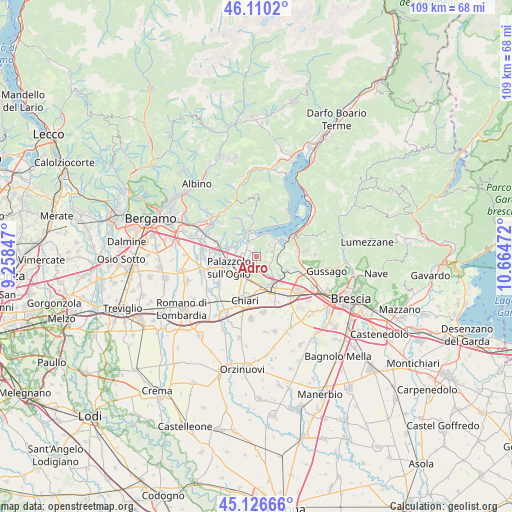
Adro GPS coordinates[2]
45° 37' 14.124" North, 9° 57' 41.724" East
| Map corner | latitude | longitude |
|---|---|---|
| Upper-left | 46.1102°, | 9.25847° |
| Center: | 45.62059°, | 9.96159° |
| Lower-right: | 45.12666°, | 10.66472° |
| Map W x H: | 109.4×109.4 km | = 68×68mi |
| max Lat: | 47.04031° ⇑22.1% North |
| Adro: | 45.62059° |
| min Lat: | ⇓77.9% South 35.50142° |
| min Long | Adro | max Long |
| 6.69888° | 9.96159° | 18.48682° |
| W 31.8%⇐ | ⇒68.2% E |
Elevation
Elevation of Adro is 246 m = 807 ft, and this is 60.7 m = 199 ft below average elevation for this country.
| Max E: |
2085 m = 6841 ft | 48.1% |
| Avg. | 306.7 m = 1006 ft | |
| Adro | 246 m = 807 ft | |
Min E: |
-4 m = -13 ft | 51.9% |
See also: Italy elevation on elevation.city.
Geographical zone
Adro is located in North temperate zone (between Tropic of Cancer and the Arctic Circle). Distance of this North polar circle is 2328.6 km =1446.9 mi to North.| Distance of | km | miles | from Adro |
|---|---|---|---|
| North Pole | 4934.5 | 3066.2 | to North |
| Arctic Circle | 2328.6 | 1446.9 | to North |
| Tropic Cancer | 2466.6 | 1532.7 | to South |
| Equator | 5072.5 | 3151.9 | to South |


Nearby cities:
15 places around Adro: (largest is in red/bold)
• Borgonato
4.4 km =2.7 mi,  89°
89°
• Capriolo
2.7 km =1.7 mi,  301°
301°
• Clusane
5.5 km =3.4 mi,  32°
32°
• Cologne
4.9 km =3 mi,  198°
198°
• Colombaro-Timoline
3.6 km =2.2 mi,  44°
44°
• Corte Franca
2.3 km =1.4 mi,  63°
63°
• Credaro
5 km =3.1 mi,  331°
331°
• Cremignane
5.4 km =3.4 mi,  53°
53°
• Erbusco
2.6 km =1.6 mi,  161°
161°
• Nigoline-Bonomelli
2.2 km =1.4 mi, 64°
• Paratico
4.3 km =2.7 mi,  356°
356°
• Sarnico
5.6 km =3.5 mi, 359°
• Tagliuno
4.8 km =3 mi, 300°
• Torbiato
2 km =1.2 mi,  119°
119°
• Villa Pedergnano
4.7 km =2.9 mi,  147°
147°
Sources, notices
• [Note1] Compared only with cities in Italy existing in our database
• [Src1] Map data: © OpenStreetMap contributors (CC-BY-SA)
• [Src2] Other city data from geonames.org with taken over terms of usage.
• [Src3] Geographical zone / Annual Mean Temperature by Robert A. Rohde @ Wikipedia
