Lambrinia geodata
Lambrinia (Lombardy) is a populated place; located in Italy in Europe/Rome (GMT+2) time zone. With population of 1,135 people, there are 6163 cities with bigger population in this country. Compared to other cities in Italy, 64% of cities are located further ↓South; 73% of cities are located further →East and 77.2% of cities have higher elevation than Lambrinia. Note1


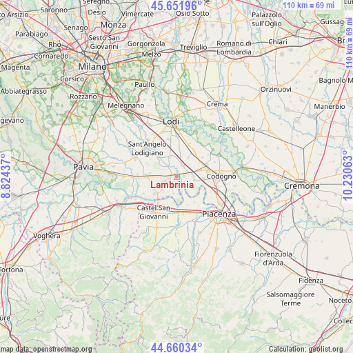
Lambrinia GPS coordinates[2]
45° 9' 29.916" North, 9° 31' 39" East
| Map corner | latitude | longitude |
|---|---|---|
| Upper-left | 45.65196°, | 8.82437° |
| Center: | 45.15831°, | 9.5275° |
| Lower-right: | 44.66034°, | 10.23063° |
| Map W x H: | 110.3×110.3 km | = 68.5×68.5mi |
| max Lat: | 47.04031° ⇑36% North |
| Lambrinia: | 45.15831° |
| min Lat: | ⇓64% South 35.50142° |
| min Long | Lambrinia | max Long |
| 6.69888° | 9.5275° | 18.48682° |
| W 27%⇐ | ⇒73% E |
Elevation
Elevation of Lambrinia is 63 m = 207 ft, and this is 243.7 m = 800 ft below average elevation for this country.
| Max E: |
2085 m = 6841 ft | 77.2% |
| Avg. | 306.7 m = 1006 ft | |
| Lambrinia | 63 m = 207 ft | |
Min E: |
-4 m = -13 ft | 22.8% |
See also: Italy elevation on elevation.city.
Geographical zone
Lambrinia is located in North temperate zone (between Tropic of Cancer and the Arctic Circle). Distance of this North polar circle is 2380 km =1478.9 mi to North.| Distance of | km | miles | from Lambrinia |
|---|---|---|---|
| North Pole | 4985.9 | 3098.1 | to North |
| Arctic Circle | 2380 | 1478.9 | to North |
| Tropic Cancer | 2415.2 | 1500.7 | to South |
| Equator | 5021.1 | 3120 | to South |


Nearby cities:
15 places around Lambrinia: (largest is in red/bold)
• Badia Pavese
6.2 km =3.9 mi,  227°
227°
• Borghetto Lodigiano
6.5 km =4 mi,  340°
340°
• Brembio
7 km =4.3 mi,  30°
30°
• Camporinaldo
4.5 km =2.8 mi,  277°
277°
• Chignolo Po
3.8 km =2.4 mi,  252°
252°
• Graffignana
7.8 km =4.8 mi,  313°
313°
• Livraga
4.1 km =2.5 mi,  21°
21°
• Mirabello
6.8 km =4.2 mi,  97°
97°
• Miradolo Terme
6.7 km =4.2 mi, 282°
• Monticelli Pavese
5.4 km =3.4 mi,  192°
192°
• Orio Litta
2.2 km =1.4 mi,  77°
77°
• Ospedaletto Lodigiano
4.2 km =2.6 mi,  73°
73°
• San Colombano al Lambro
4 km =2.5 mi, 313°
• San Martino Pizzolano
7.4 km =4.6 mi,  85°
85°
• Senna Lodigiana
5.3 km =3.3 mi, 99°
Sources, notices
• [Note1] Compared only with cities in Italy existing in our database
• [Src1] Map data: © OpenStreetMap contributors (CC-BY-SA)
• [Src2] Other city data from geonames.org with taken over terms of usage.
• [Src3] Geographical zone / Annual Mean Temperature by Robert A. Rohde @ Wikipedia
