Parona geodata
Parona (Lombardy) is a seat of a third-order administrative division; located in Italy in Europe/Rome (GMT+2) time zone. With population of 1,776 people, there are 4525 cities with bigger population in this country. Compared to other cities in Italy, 67% of cities are located further ↓South; 84.8% of cities are located further →East and 67.8% of cities have higher elevation than Parona. Note1


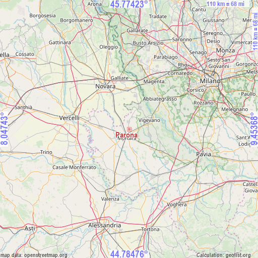
Parona GPS coordinates[2]
45° 16' 53.94" North, 8° 45' 1.98" East
| Map corner | latitude | longitude |
|---|---|---|
| Upper-left | 45.77423°, | 8.04743° |
| Center: | 45.28165°, | 8.75055° |
| Lower-right: | 44.78476°, | 9.45368° |
| Map W x H: | 110×110 km | = 68.4×68.4mi |
| max Lat: | 47.04031° ⇑33% North |
| Parona: | 45.28165° |
| min Lat: | ⇓67% South 35.50142° |
| min Long | Parona | max Long |
| 6.69888° | 8.75055° | 18.48682° |
| W 15.2%⇐ | ⇒84.8% E |
Elevation
Elevation of Parona is 110 m = 361 ft, and this is 196.7 m = 645 ft below average elevation for this country.
| Max E: |
2085 m = 6841 ft | 67.8% |
| Avg. | 306.7 m = 1006 ft | |
| Parona | 110 m = 361 ft | |
Min E: |
-4 m = -13 ft | 32.2% |
See also: Italy elevation on elevation.city.
Geographical zone
Parona is located in North temperate zone (between Tropic of Cancer and the Arctic Circle). Distance of this North polar circle is 2366.3 km =1470.4 mi to North.| Distance of | km | miles | from Parona |
|---|---|---|---|
| North Pole | 4972.2 | 3089.6 | to North |
| Arctic Circle | 2366.3 | 1470.4 | to North |
| Tropic Cancer | 2428.9 | 1509.2 | to South |
| Equator | 5034.8 | 3128.5 | to South |


Nearby cities:
15 places around Parona: (largest is in red/bold)
• Albonese
3.7 km =2.3 mi,  289°
289°
• Borgolavezzaro
5.8 km =3.6 mi,  316°
316°
• Castello d'Agogna
7.2 km =4.5 mi,  223°
223°
• Ceretto Lomellina
7.3 km =4.5 mi,  236°
236°
• Cergnago
9.4 km =5.8 mi,  169°
169°
• Cilavegna
3.3 km =2.1 mi,  351°
351°
• Gambolò
8.7 km =5.4 mi,  104°
104°
• Gravellona
5.2 km =3.2 mi,  11°
11°
• Mortara
3.8 km =2.4 mi,  200°
200°
• Nicorvo
6.5 km =4 mi,  273°
273°
• Olevano di Lomellina
8 km =5 mi, 198°
• Remondò
6.3 km =3.9 mi,  138°
138°
• Sant'Angelo Lomellina
9.3 km =5.8 mi,  245°
245°
• Tornaco
8.7 km =5.4 mi,  342°
342°
• Vigevano
8.9 km =5.5 mi,  66°
66°
Sources, notices
• [Note1] Compared only with cities in Italy existing in our database
• [Src1] Map data: © OpenStreetMap contributors (CC-BY-SA)
• [Src2] Other city data from geonames.org with taken over terms of usage.
• [Src3] Geographical zone / Annual Mean Temperature by Robert A. Rohde @ Wikipedia
