Belcastro geodata
Belcastro (Calabria) is a seat of a third-order administrative division; located in Italy in Europe/Rome (GMT+2) time zone. With population of 1,155 people, there are 6099 cities with bigger population in this country. Compared to other cities in Italy, 92.5% of cities are located further ↑North; 97.5% of cities are located further ←West and 76% of cities have lower elevation than Belcastro. Note1


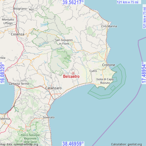
Belcastro GPS coordinates[2]
39° 1' 4.764" North, 16° 47' 11.076" East
| Map corner | latitude | longitude |
|---|---|---|
| Upper-left | 39.56217°, | 16.08329° |
| Center: | 39.01799°, | 16.78641° |
| Lower-right: | 38.46959°, | 17.48954° |
| Map W x H: | 121.5×121.5 km | = 75.5×75.5mi |
| max Lat: | 47.04031° ⇑92.5% North |
| Belcastro: | 39.01799° |
| min Lat: | ⇓7.5% South 35.50142° |
| min Long | Belcastro | max Long |
| 6.69888° | 16.78641° | 18.48682° |
| W 97.5%⇐ | ⇒2.5% E |
Elevation
Elevation of Belcastro is 465 m = 1526 ft, and this is 158.3 m = 519 ft above average elevation for this country.
| Max E: |
2085 m = 6841 ft | 24% |
| Belcastro | 465 m 1526 ft | |
| Avg. | 306.7 m = 1006 ft | |
Min E: |
-4 m = -13 ft | 76% |
See also: Italy elevation on elevation.city.
Geographical zone
Belcastro is located in North temperate zone (between Tropic of Cancer and the Arctic Circle). Distance of this Northern Tropic circle is 1732.5 km =1076.5 mi to South.| Distance of | km | miles | from Belcastro |
|---|---|---|---|
| North Pole | 5668.7 | 3522.4 | to North |
| Arctic Circle | 3062.8 | 1903.1 | to North |
| Tropic Cancer | 1732.5 | 1076.5 | to South |
| Equator | 4338.4 | 2695.8 | to South |


Nearby cities:
15 places around Belcastro: (largest is in red/bold)
• Andali
1.6 km =1 mi,  248°
248°
• Botricello
11.6 km =7.2 mi,  147°
147°
• Cerva
3.6 km =2.2 mi,  280°
280°
• Cropani
5.7 km =3.5 mi,  185°
185°
• Cropani Marina
10.7 km =6.6 mi,  168°
168°
• Foresta
9.3 km =5.8 mi,  14°
14°
• Marcedusa
4.4 km =2.7 mi,  77°
77°
• Mesoraca
6.8 km =4.2 mi,  1°
1°
• Petilia Policastro
10.6 km =6.6 mi,  357°
357°
• Petronà
3.8 km =2.4 mi,  319°
319°
• Piano D'Agazio
11.7 km =7.3 mi, 193°
• Sersale
5 km =3.1 mi,  259°
259°
• Soveria Simeri
12 km =7.5 mi,  230°
230°
• Uria
12.8 km =8 mi,  203°
203°
• Zagarise
10.7 km =6.6 mi, 259°
Sources, notices
• [Note1] Compared only with cities in Italy existing in our database
• [Src1] Map data: © OpenStreetMap contributors (CC-BY-SA)
• [Src2] Other city data from geonames.org with taken over terms of usage.
• [Src3] Geographical zone / Annual Mean Temperature by Robert A. Rohde @ Wikipedia
