Foresta geodata
Foresta (Calabria) is a populated place; located in Italy in Europe/Rome (GMT+2) time zone. With population of 1,218 people, there are 5899 cities with bigger population in this country. Compared to other cities in Italy, 92.2% of cities are located further ↑North; 97.6% of cities are located further ←West and 60% of cities have lower elevation than Foresta. Note1
Administrative division(s):
- Level 1: Calabria
- Level 2: Provincia di Crotone
- Level 3: Petilia Policastro


Foresta GPS coordinates[2]
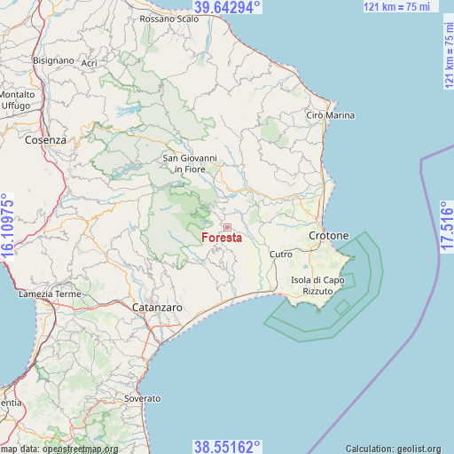
39° 5' 57.804" North, 16° 48' 46.332" East
| Map corner | latitude | longitude |
|---|---|---|
| Upper-left | 39.64294°, | 16.10975° |
| Center: | 39.09939°, | 16.81287° |
| Lower-right: | 38.55162°, | 17.516° |
| Map W x H: | 121.3×121.3 km | = 75.4×75.4mi |
| max Lat: | 47.04031° ⇑92.2% North |
| Foresta: | 39.09939° |
| min Lat: | ⇓7.8% South 35.50142° |
| min Long | Foresta | max Long |
| 6.69888° | 16.81287° | 18.48682° |
| W 97.6%⇐ | ⇒2.4% E |
Elevation
Elevation of Foresta is 299 m = 981 ft, and this is 7.7 m = 25 ft below average elevation for this country.
| Max E: |
2085 m = 6841 ft | 40% |
| Avg. | 306.7 m = 1006 ft | |
| Foresta | 299 m = 981 ft | |
Min E: |
-4 m = -13 ft | 60% |
See also: Italy elevation on elevation.city.
Geographical zone
Foresta is located in North temperate zone (between Tropic of Cancer and the Arctic Circle). Distance of this Northern Tropic circle is 1741.5 km =1082.1 mi to South.| Distance of | km | miles | from Foresta |
|---|---|---|---|
| North Pole | 5659.6 | 3516.7 | to North |
| Arctic Circle | 3053.7 | 1897.5 | to North |
| Tropic Cancer | 1741.5 | 1082.1 | to South |
| Equator | 4347.4 | 2701.3 | to South |


Nearby cities:
15 places around Foresta: (largest is in red/bold)
• Andali
10.3 km =6.4 mi,  201°
201°
• Belcastro
9.3 km =5.8 mi,  194°
194°
• Belvedere Spinello
13.8 km =8.6 mi,  29°
29°
• Cerva
10.2 km =6.3 mi,  214°
214°
• Cotronei
7.4 km =4.6 mi,  335°
335°
• Marcedusa
8.3 km =5.2 mi,  166°
166°
• Mesoraca
3.1 km =1.9 mi,  224°
224°
• Pagliarelle
7 km =4.3 mi,  310°
310°
• Petilia Policastro
3.1 km =1.9 mi,  299°
299°
• Petronà
7.8 km =4.8 mi, 217°
• Roccabernarda
5.6 km =3.5 mi,  48°
48°
• San Mauro Marchesato
9.8 km =6.1 mi,  85°
85°
• Santa Severina
10 km =6.2 mi,  57°
57°
• Scandale
13.1 km =8.1 mi,  78°
78°
• Sersale
12.3 km =7.6 mi, 215°
Sources, notices
• [Note1] Compared only with cities in Italy existing in our database
• [Src1] Map data: © OpenStreetMap contributors (CC-BY-SA)
• [Src2] Other city data from geonames.org with taken over terms of usage.
• [Src3] Geographical zone / Annual Mean Temperature by Robert A. Rohde @ Wikipedia
