Mairago geodata
Mairago (Lombardy) is a seat of a third-order administrative division; located in Italy in Europe/Rome (GMT+2) time zone. With population of 693 people, there are 8345 cities with bigger population in this country. Compared to other cities in Italy, 66.2% of cities are located further ↓South; 72.3% of cities are located further →East and 76.1% of cities have higher elevation than Mairago. Note1


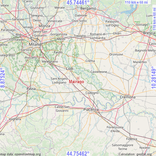
Mairago GPS coordinates[2]
45° 15' 6.372" North, 9° 34' 42.096" East
| Map corner | latitude | longitude |
|---|---|---|
| Upper-left | 45.74461°, | 8.87524° |
| Center: | 45.25177°, | 9.57836° |
| Lower-right: | 44.75462°, | 10.28149° |
| Map W x H: | 110.1×110.1 km | = 68.4×68.4mi |
| max Lat: | 47.04031° ⇑33.8% North |
| Mairago: | 45.25177° |
| min Lat: | ⇓66.2% South 35.50142° |
| min Long | Mairago | max Long |
| 6.69888° | 9.57836° | 18.48682° |
| W 27.7%⇐ | ⇒72.3% E |
Elevation
Elevation of Mairago is 69 m = 226 ft, and this is 237.7 m = 780 ft below average elevation for this country.
| Max E: |
2085 m = 6841 ft | 76.1% |
| Avg. | 306.7 m = 1006 ft | |
| Mairago | 69 m = 226 ft | |
Min E: |
-4 m = -13 ft | 23.9% |
See also: Italy elevation on elevation.city.
Geographical zone
Mairago is located in North temperate zone (between Tropic of Cancer and the Arctic Circle). Distance of this North polar circle is 2369.6 km =1472.4 mi to North.| Distance of | km | miles | from Mairago |
|---|---|---|---|
| North Pole | 4975.5 | 3091.6 | to North |
| Arctic Circle | 2369.6 | 1472.4 | to North |
| Tropic Cancer | 2425.6 | 1507.2 | to South |
| Equator | 5031.5 | 3126.4 | to South |


Nearby cities:
15 places around Mairago: (largest is in red/bold)
• Abbadia Cerreto
6.8 km =4.2 mi,  10°
10°
• Basiasco
1.7 km =1.1 mi,  31°
31°
• Bertonico
7.3 km =4.5 mi,  106°
106°
• Borghetto Lodigiano
7.5 km =4.7 mi,  235°
235°
• Brembio
4.4 km =2.7 mi,  186°
186°
• Cavenago d'Adda
3.8 km =2.4 mi,  24°
24°
• Livraga
7.1 km =4.4 mi,  200°
200°
• Massalengo-Motta Vigana
7.1 km =4.4 mi,  282°
282°
• Ossago Lodigiano
3.4 km =2.1 mi,  251°
251°
• San Martino in Strada
4.8 km =3 mi,  302°
302°
• Secugnago
2.6 km =1.6 mi,  151°
151°
• Terranova dei Passerini
7.7 km =4.8 mi,  121°
121°
• Terraverde-Corte Palasio
7.2 km =4.5 mi,  349°
349°
• Turano Lodigiano
3.5 km =2.2 mi,  97°
97°
• Zorlesco
6.4 km =4 mi, 152°
Sources, notices
• [Note1] Compared only with cities in Italy existing in our database
• [Src1] Map data: © OpenStreetMap contributors (CC-BY-SA)
• [Src2] Other city data from geonames.org with taken over terms of usage.
• [Src3] Geographical zone / Annual Mean Temperature by Robert A. Rohde @ Wikipedia
