Secugnago geodata
Secugnago (Lombardy) is a seat of a third-order administrative division; located in Italy in Europe/Rome (GMT+2) time zone. With population of 1,852 people, there are 4408 cities with bigger population in this country. Compared to other cities in Italy, 65.6% of cities are located further ↓South; 72.1% of cities are located further →East and 76.8% of cities have higher elevation than Secugnago. Note1


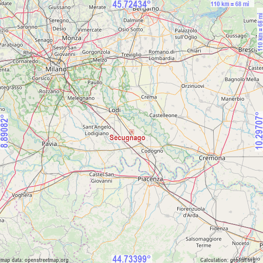
Secugnago GPS coordinates[2]
45° 13' 52.752" North, 9° 35' 38.184" East
| Map corner | latitude | longitude |
|---|---|---|
| Upper-left | 45.72434°, | 8.89082° |
| Center: | 45.23132°, | 9.59394° |
| Lower-right: | 44.73399°, | 10.29707° |
| Map W x H: | 110.1×110.1 km | = 68.4×68.4mi |
| max Lat: | 47.04031° ⇑34.4% North |
| Secugnago: | 45.23132° |
| min Lat: | ⇓65.6% South 35.50142° |
| min Long | Secugnago | max Long |
| 6.69888° | 9.59394° | 18.48682° |
| W 27.9%⇐ | ⇒72.1% E |
Elevation
Elevation of Secugnago is 65 m = 213 ft, and this is 241.7 m = 793 ft below average elevation for this country.
| Max E: |
2085 m = 6841 ft | 76.8% |
| Avg. | 306.7 m = 1006 ft | |
| Secugnago | 65 m = 213 ft | |
Min E: |
-4 m = -13 ft | 23.2% |
See also: Italy elevation on elevation.city.
Geographical zone
Secugnago is located in North temperate zone (between Tropic of Cancer and the Arctic Circle). Distance of this North polar circle is 2371.9 km =1473.8 mi to North.| Distance of | km | miles | from Secugnago |
|---|---|---|---|
| North Pole | 4977.8 | 3093.1 | to North |
| Arctic Circle | 2371.9 | 1473.8 | to North |
| Tropic Cancer | 2423.3 | 1505.8 | to South |
| Equator | 5029.3 | 3125.1 | to South |


Nearby cities:
15 places around Secugnago: (largest is in red/bold)
• Basiasco
3.8 km =2.4 mi,  354°
354°
• Bertonico
5.8 km =3.6 mi,  88°
88°
• Borghetto Lodigiano
7.7 km =4.8 mi,  254°
254°
• Brembio
2.7 km =1.7 mi,  218°
218°
• Casalpusterlengo
7.2 km =4.5 mi,  143°
143°
• Cavenago d'Adda
5.7 km =3.5 mi,  3°
3°
• Fornaci
7.5 km =4.7 mi,  118°
118°
• Livraga
5.7 km =3.5 mi, 220°
• Mairago
2.6 km =1.6 mi,  331°
331°
• Ospedaletto Lodigiano
7.1 km =4.4 mi,  189°
189°
• Ossago Lodigiano
4.6 km =2.9 mi,  285°
285°
• San Martino in Strada
7.2 km =4.5 mi,  312°
312°
• Terranova dei Passerini
5.6 km =3.5 mi,  108°
108°
• Turano Lodigiano
2.9 km =1.8 mi,  50°
50°
• Zorlesco
3.9 km =2.4 mi,  153°
153°
Sources, notices
• [Note1] Compared only with cities in Italy existing in our database
• [Src1] Map data: © OpenStreetMap contributors (CC-BY-SA)
• [Src2] Other city data from geonames.org with taken over terms of usage.
• [Src3] Geographical zone / Annual Mean Temperature by Robert A. Rohde @ Wikipedia
