Neviglie geodata
Neviglie (Piedmont) is a seat of a third-order administrative division; located in Italy in Europe/Rome (GMT+2) time zone. With population of 105 people, there are 11421 cities with bigger population in this country. Compared to other cities in Italy, 54.1% of cities are located further ↓South; 92% of cities are located further →East and 75.1% of cities have lower elevation than Neviglie. Note1


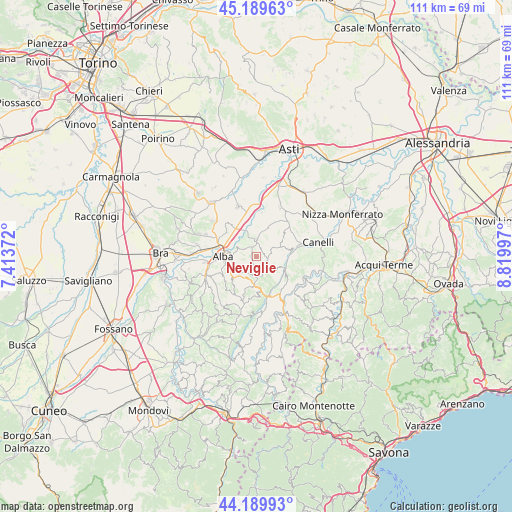
Neviglie GPS coordinates[2]
44° 41' 30.984" North, 8° 7' 0.624" East
| Map corner | latitude | longitude |
|---|---|---|
| Upper-left | 45.18963°, | 7.41372° |
| Center: | 44.69194°, | 8.11684° |
| Lower-right: | 44.18993°, | 8.81997° |
| Map W x H: | 111.2×111.2 km | = 69.1×69.1mi |
| max Lat: | 47.04031° ⇑45.9% North |
| Neviglie: | 44.69194° |
| min Lat: | ⇓54.1% South 35.50142° |
| min Long | Neviglie | max Long |
| 6.69888° | 8.11684° | 18.48682° |
| W 8%⇐ | ⇒92% E |
Elevation
Elevation of Neviglie is 453 m = 1486 ft, and this is 146.3 m = 480 ft above average elevation for this country.
| Max E: |
2085 m = 6841 ft | 24.9% |
| Neviglie | 453 m 1486 ft | |
| Avg. | 306.7 m = 1006 ft | |
Min E: |
-4 m = -13 ft | 75.1% |
See also: Italy elevation on elevation.city.
Geographical zone
Neviglie is located in North temperate zone (between Tropic of Cancer and the Arctic Circle). Distance of this Northern Tropic circle is 2363.4 km =1468.5 mi to South.| Distance of | km | miles | from Neviglie |
|---|---|---|---|
| North Pole | 5037.8 | 3130.3 | to North |
| Arctic Circle | 2431.9 | 1511.1 | to North |
| Tropic Cancer | 2363.4 | 1468.5 | to South |
| Equator | 4969.3 | 3087.8 | to South |


Nearby cities:
15 places around Neviglie: (largest is in red/bold)
• Alba
6.6 km =4.1 mi,  277°
277°
• Barbaresco
4.4 km =2.7 mi,  321°
321°
• Benevello
7 km =4.3 mi,  187°
187°
• Bricco di Neive
2.6 km =1.6 mi,  31°
31°
• Camo
6.1 km =3.8 mi,  86°
86°
• Castagnole delle Lanze
6.9 km =4.3 mi,  21°
21°
• Castiglione Tinella
6.9 km =4.3 mi,  57°
57°
• Coazzolo
4.6 km =2.9 mi, 28°
• Cossano Belbo
7 km =4.3 mi,  111°
111°
• Mango
2.6 km =1.6 mi,  99°
99°
• Neive-Borgonovo
3.6 km =2.2 mi,  1°
1°
• Ricca
6.6 km =4.1 mi,  238°
238°
• Treiso
2.3 km =1.4 mi,  263°
263°
• Trezzo Tinella
1.8 km =1.1 mi,  203°
203°
• Vaccheria
7 km =4.3 mi,  303°
303°
Sources, notices
• [Note1] Compared only with cities in Italy existing in our database
• [Src1] Map data: © OpenStreetMap contributors (CC-BY-SA)
• [Src2] Other city data from geonames.org with taken over terms of usage.
• [Src3] Geographical zone / Annual Mean Temperature by Robert A. Rohde @ Wikipedia
