Barbaresco geodata
Barbaresco (Piedmont) is a seat of a third-order administrative division; located in Italy in Europe/Rome (GMT+2) time zone. With population of 290 people, there are 10710 cities with bigger population in this country. Compared to other cities in Italy, 54.7% of cities are located further ↓South; 92.5% of cities are located further →East and 52.5% of cities have lower elevation than Barbaresco. Note1


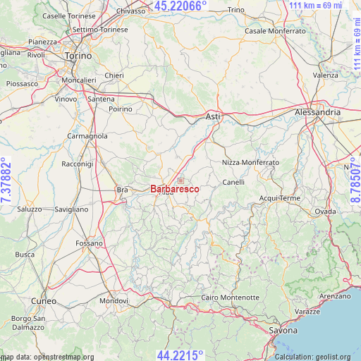
Barbaresco GPS coordinates[2]
44° 43' 23.664" North, 8° 4' 54.984" East
| Map corner | latitude | longitude |
|---|---|---|
| Upper-left | 45.22066°, | 7.37882° |
| Center: | 44.72324°, | 8.08194° |
| Lower-right: | 44.2215°, | 8.78507° |
| Map W x H: | 111.1×111.1 km | = 69×69mi |
| max Lat: | 47.04031° ⇑45.3% North |
| Barbaresco: | 44.72324° |
| min Lat: | ⇓54.7% South 35.50142° |
| min Long | Barbaresco | max Long |
| 6.69888° | 8.08194° | 18.48682° |
| W 7.5%⇐ | ⇒92.5% E |
Elevation
Elevation of Barbaresco is 250 m = 820 ft, and this is 56.7 m = 186 ft below average elevation for this country.
| Max E: |
2085 m = 6841 ft | 47.5% |
| Avg. | 306.7 m = 1006 ft | |
| Barbaresco | 250 m = 820 ft | |
Min E: |
-4 m = -13 ft | 52.5% |
See also: Italy elevation on elevation.city.
Geographical zone
Barbaresco is located in North temperate zone (between Tropic of Cancer and the Arctic Circle). Distance of this Northern Tropic circle is 2366.8 km =1470.7 mi to South.| Distance of | km | miles | from Barbaresco |
|---|---|---|---|
| North Pole | 5034.3 | 3128.2 | to North |
| Arctic Circle | 2428.4 | 1508.9 | to North |
| Tropic Cancer | 2366.8 | 1470.7 | to South |
| Equator | 4972.8 | 3090 | to South |


Nearby cities:
15 places around Barbaresco: (largest is in red/bold)
• Alba
4.5 km =2.8 mi,  235°
235°
• Baraccone
3 km =1.9 mi,  329°
329°
• Bricco di Neive
4.3 km =2.7 mi,  107°
107°
• Castagnito
5.3 km =3.3 mi,  311°
311°
• Coazzolo
5 km =3.1 mi,  83°
83°
• Guarene
4.1 km =2.5 mi,  296°
296°
• Magliano Alfieri
5.2 km =3.2 mi,  349°
349°
• Mussotto
3.8 km =2.4 mi,  260°
260°
• Neive-Borgonovo
2.8 km =1.7 mi,  88°
88°
• Neviglie
4.4 km =2.7 mi,  141°
141°
• San Giuseppe
3.9 km =2.4 mi,  323°
323°
• Sant'Antonio
4.1 km =2.5 mi, 346°
• Treiso
3.8 km =2.4 mi,  172°
172°
• Trezzo Tinella
5.5 km =3.4 mi,  158°
158°
• Vaccheria
3.1 km =1.9 mi,  277°
277°
Sources, notices
• [Note1] Compared only with cities in Italy existing in our database
• [Src1] Map data: © OpenStreetMap contributors (CC-BY-SA)
• [Src2] Other city data from geonames.org with taken over terms of usage.
• [Src3] Geographical zone / Annual Mean Temperature by Robert A. Rohde @ Wikipedia
