Carentino geodata
Carentino (Piedmont) is a seat of a third-order administrative division; located in Italy in Europe/Rome (GMT+2) time zone. With population of 285 people, there are 10737 cities with bigger population in this country. Compared to other cities in Italy, 56.7% of cities are located further ↓South; 88.2% of cities are located further →East and 60.9% of cities have higher elevation than Carentino. Note1


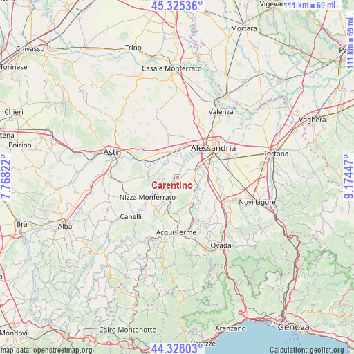
Carentino GPS coordinates[2]
44° 49' 43.86" North, 8° 28' 16.824" East
| Map corner | latitude | longitude |
|---|---|---|
| Upper-left | 45.32536°, | 7.76822° |
| Center: | 44.82885°, | 8.47134° |
| Lower-right: | 44.32803°, | 9.17447° |
| Map W x H: | 110.9×110.9 km | = 68.9×68.9mi |
| max Lat: | 47.04031° ⇑43.3% North |
| Carentino: | 44.82885° |
| min Lat: | ⇓56.7% South 35.50142° |
| min Long | Carentino | max Long |
| 6.69888° | 8.47134° | 18.48682° |
| W 11.8%⇐ | ⇒88.2% E |
Elevation
Elevation of Carentino is 156 m = 512 ft, and this is 150.7 m = 494 ft below average elevation for this country.
| Max E: |
2085 m = 6841 ft | 60.9% |
| Avg. | 306.7 m = 1006 ft | |
| Carentino | 156 m = 512 ft | |
Min E: |
-4 m = -13 ft | 39.1% |
See also: Italy elevation on elevation.city.
Geographical zone
Carentino is located in North temperate zone (between Tropic of Cancer and the Arctic Circle). Distance of this Northern Tropic circle is 2378.6 km =1478 mi to South.| Distance of | km | miles | from Carentino |
|---|---|---|---|
| North Pole | 5022.6 | 3120.9 | to North |
| Arctic Circle | 2416.7 | 1501.7 | to North |
| Tropic Cancer | 2378.6 | 1478 | to South |
| Equator | 4984.5 | 3097.2 | to South |


Nearby cities:
15 places around Carentino: (largest is in red/bold)
• Bergamasco
1.3 km =0.8 mi,  262°
262°
• Borgoratto Alessandrino
5.4 km =3.4 mi,  81°
81°
• Bruno
4.7 km =2.9 mi,  211°
211°
• Cantalupo
7.7 km =4.8 mi,  56°
56°
• Castellazzo Bormida
8.6 km =5.3 mi, 79°
• Castelnuovo Belbo
5.6 km =3.5 mi,  236°
236°
• Felizzano
8.3 km =5.2 mi,  340°
340°
• Frascaro
4.7 km =2.9 mi,  94°
94°
• Gamalero
6 km =3.7 mi,  112°
112°
• Ghiare-Madonna
8 km =5 mi,  252°
252°
• Incisa Scapaccino
7.9 km =4.9 mi, 252°
• Maranzana
7.6 km =4.7 mi,  175°
175°
• Masio
6.8 km =4.2 mi,  312°
312°
• Mombaruzzo
6.6 km =4.1 mi,  195°
195°
• Oviglio
3.8 km =2.4 mi,  19°
19°
Sources, notices
• [Note1] Compared only with cities in Italy existing in our database
• [Src1] Map data: © OpenStreetMap contributors (CC-BY-SA)
• [Src2] Other city data from geonames.org with taken over terms of usage.
• [Src3] Geographical zone / Annual Mean Temperature by Robert A. Rohde @ Wikipedia
