Garbagna geodata
Garbagna (Piedmont) is a seat of a third-order administrative division; located in Italy in Europe/Rome (GMT+2) time zone. With population of 428 people, there are 10171 cities with bigger population in this country. Compared to other cities in Italy, 55.8% of cities are located further ↓South; 81.3% of cities are located further →East and 58.9% of cities have lower elevation than Garbagna. Note1


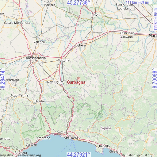
Garbagna GPS coordinates[2]
44° 46' 49.62" North, 8° 59' 52.296" East
| Map corner | latitude | longitude |
|---|---|---|
| Upper-left | 45.27738°, | 8.29474° |
| Center: | 44.78045°, | 8.99786° |
| Lower-right: | 44.27921°, | 9.70099° |
| Map W x H: | 111×111 km | = 69×69mi |
| max Lat: | 47.04031° ⇑44.2% North |
| Garbagna: | 44.78045° |
| min Lat: | ⇓55.8% South 35.50142° |
| min Long | Garbagna | max Long |
| 6.69888° | 8.99786° | 18.48682° |
| W 18.7%⇐ | ⇒81.3% E |
Elevation
Elevation of Garbagna is 291 m = 955 ft, and this is 15.7 m = 52 ft below average elevation for this country.
| Max E: |
2085 m = 6841 ft | 41.1% |
| Avg. | 306.7 m = 1006 ft | |
| Garbagna | 291 m = 955 ft | |
Min E: |
-4 m = -13 ft | 58.9% |
See also: Italy elevation on elevation.city.
Geographical zone
Garbagna is located in North temperate zone (between Tropic of Cancer and the Arctic Circle). Distance of this Northern Tropic circle is 2373.2 km =1474.6 mi to South.| Distance of | km | miles | from Garbagna |
|---|---|---|---|
| North Pole | 5027.9 | 3124.2 | to North |
| Arctic Circle | 2422.1 | 1505 | to North |
| Tropic Cancer | 2373.2 | 1474.6 | to South |
| Equator | 4979.1 | 3093.9 | to South |


Nearby cities:
15 places around Garbagna: (largest is in red/bold)
• Avolasca
3.6 km =2.2 mi,  314°
314°
• Borghetto di Borbera
7.1 km =4.4 mi,  217°
217°
• Brignano
5 km =3.1 mi,  41°
41°
• Cantalupo Ligure
7.9 km =4.9 mi,  151°
151°
• Carezzano Maggiore
8.2 km =5.1 mi,  291°
291°
• Casasco
5.2 km =3.2 mi,  6°
6°
• Castellania
5.7 km =3.5 mi, 290°
• Costa Vescovato
6.9 km =4.3 mi, 305°
• Dernice
4.4 km =2.7 mi,  110°
110°
• Momperone
7.1 km =4.4 mi,  23°
23°
• Montegioco
7.4 km =4.6 mi,  337°
337°
• Montemarzino
7.6 km =4.7 mi,  357°
357°
• San Sebastiano Curone
5.3 km =3.3 mi,  82°
82°
• Sant'Agata Fossili
6.1 km =3.8 mi,  274°
274°
• Torreratti-Persi
5.8 km =3.6 mi,  205°
205°
Sources, notices
• [Note1] Compared only with cities in Italy existing in our database
• [Src1] Map data: © OpenStreetMap contributors (CC-BY-SA)
• [Src2] Other city data from geonames.org with taken over terms of usage.
• [Src3] Geographical zone / Annual Mean Temperature by Robert A. Rohde @ Wikipedia
