San Giorgio delle Pertiche geodata
San Giorgio delle Pertiche (Veneto) is a seat of a third-order administrative division; located in Italy in Europe/Rome (GMT+2) time zone. With population of 7,009 people, there are 1397 cities with bigger population in this country. Compared to other cities in Italy, 75% of cities are located further ↓South; 54.4% of cities are located further ←West and 87.8% of cities have higher elevation than San Giorgio delle Pertiche. Note1
Administrative division(s):
- Level 1: Veneto
- Level 2: Provincia di Padova
- Level 3: San Giorgio delle Pertiche
Current local time in San Giorgio delle Pertiche:
10:07 PM, SundayDifference from your time zone: hours


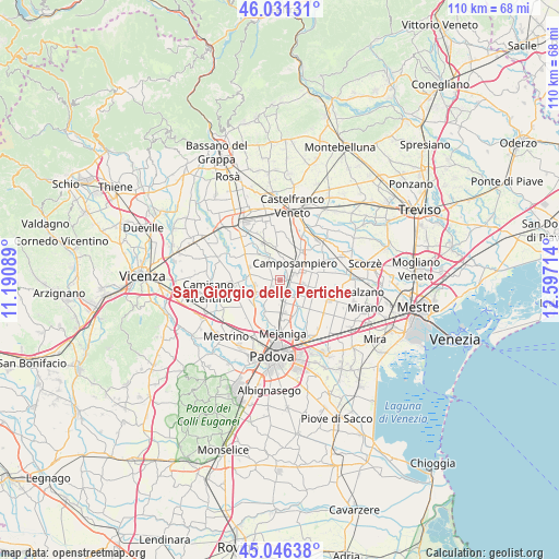
San Giorgio delle Pertiche GPS coordinates[2]
45° 32' 27.6" North, 11° 53' 38.436" East
| Map corner | latitude | longitude |
|---|---|---|
| Upper-left | 46.03131°, | 11.19089° |
| Center: | 45.541°, | 11.89401° |
| Lower-right: | 45.04638°, | 12.59714° |
| Map W x H: | 109.5×109.5 km | = 68×68mi |
| max Lat: | 47.04031° ⇑25% North |
| San Giorgio delle Pertiche: | 45.541° |
| min Lat: | ⇓75% South 35.50142° |
| min Long | San Giorgio del | max Long |
| 6.69888° | 11.89401° | 18.48682° |
| W 54.4%⇐ | ⇒45.6% E |
Elevation
Elevation of San Giorgio delle Pertiche is 23 m = 75 ft, and this is 283.7 m = 931 ft below average elevation for this country.
| Max E: |
2085 m = 6841 ft | 87.8% |
| Avg. | 306.7 m = 1006 ft | |
| San Giorgio delle Pertiche | 23 m = 75 ft | |
Min E: |
-4 m = -13 ft | 12.2% |
See also: Italy elevation on elevation.city.
Geographical zone
San Giorgio delle Pertiche is located in North temperate zone (between Tropic of Cancer and the Arctic Circle). Distance of this North polar circle is 2337.5 km =1452.5 mi to North.| Distance of | km | miles | from San Giorgio delle Pertiche |
|---|---|---|---|
| North Pole | 4943.4 | 3071.7 | to North |
| Arctic Circle | 2337.5 | 1452.5 | to North |
| Tropic Cancer | 2457.8 | 1527.2 | to South |
| Equator | 5063.7 | 3146.4 | to South |


Nearby cities:
15 places around San Giorgio delle Pertiche: (largest is in red/bold)
• Borgoricco-San Michele delle Badesse-Sant'Eufemia
3.7 km =2.3 mi,  99°
99°
• Campo San Martino
5.2 km =3.2 mi,  279°
279°
• Campodarsego
5.2 km =3.2 mi,  155°
155°
• Camposampiero
4.1 km =2.5 mi,  51°
51°
• Cavino
2.8 km =1.7 mi,  195°
195°
• Curtarolo
4.8 km =3 mi,  246°
246°
• Pieve
5 km =3.1 mi,  267°
267°
• Prisco-Sandrin Piccolo
6.6 km =4.1 mi, 204°
• Rustega
7.1 km =4.4 mi,  63°
63°
• Santa Giustina in Colle
3.8 km =2.4 mi,  7°
7°
• Santa Maria di Non
4.4 km =2.7 mi,  225°
225°
• Tavo
5.2 km =3.2 mi,  209°
209°
• Terraglione
6.3 km =3.9 mi,  178°
178°
• Vaccarino
6.5 km =4 mi,  235°
235°
• Villa del Conte
5.6 km =3.5 mi,  331°
331°
Sources, notices
• [Note1] Compared only with cities in Italy existing in our database
• [Src1] Map data: © OpenStreetMap contributors (CC-BY-SA)
• [Src2] Other city data from geonames.org with taken over terms of usage.
• [Src3] Geographical zone / Annual Mean Temperature by Robert A. Rohde @ Wikipedia
