Cavino geodata
Cavino (Veneto) is a populated place; located in Italy in Europe/Rome (GMT+2) time zone. With population of 1,701 people, there are 4663 cities with bigger population in this country. Compared to other cities in Italy, 74.2% of cities are located further ↓South; 54.3% of cities are located further ←West and 89.6% of cities have higher elevation than Cavino. Note1
Administrative division(s):
- Level 1: Veneto
- Level 2: Provincia di Padova
- Level 3: San Giorgio delle Pertiche


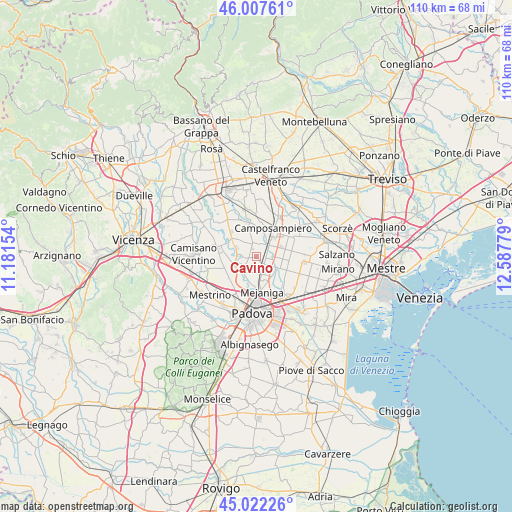
Cavino GPS coordinates[2]
45° 31' 1.524" North, 11° 53' 4.776" East
| Map corner | latitude | longitude |
|---|---|---|
| Upper-left | 46.00761°, | 11.18154° |
| Center: | 45.51709°, | 11.88466° |
| Lower-right: | 45.02226°, | 12.58779° |
| Map W x H: | 109.6×109.6 km | = 68.1×68.1mi |
| max Lat: | 47.04031° ⇑25.8% North |
| Cavino: | 45.51709° |
| min Lat: | ⇓74.2% South 35.50142° |
| min Long | Cavino | max Long |
| 6.69888° | 11.88466° | 18.48682° |
| W 54.3%⇐ | ⇒45.7% E |
Elevation
Elevation of Cavino is 19 m = 62 ft, and this is 287.7 m = 944 ft below average elevation for this country.
| Max E: |
2085 m = 6841 ft | 89.6% |
| Avg. | 306.7 m = 1006 ft | |
| Cavino | 19 m = 62 ft | |
Min E: |
-4 m = -13 ft | 10.4% |
See also: Italy elevation on elevation.city.
Geographical zone
Cavino is located in North temperate zone (between Tropic of Cancer and the Arctic Circle). Distance of this North polar circle is 2340.1 km =1454.1 mi to North.| Distance of | km | miles | from Cavino |
|---|---|---|---|
| North Pole | 4946 | 3073.3 | to North |
| Arctic Circle | 2340.1 | 1454.1 | to North |
| Tropic Cancer | 2455.1 | 1525.5 | to South |
| Equator | 5061 | 3144.8 | to South |


Nearby cities:
15 places around Cavino: (largest is in red/bold)
• Borgoricco-San Michele delle Badesse-Sant'Eufemia
4.8 km =3 mi,  65°
65°
• Campo San Martino
5.6 km =3.5 mi,  308°
308°
• Campodarsego
3.6 km =2.2 mi,  125°
125°
• Camposampiero
6.5 km =4 mi,  37°
37°
• Curtarolo
3.8 km =2.4 mi,  281°
281°
• Limena
6.1 km =3.8 mi,  209°
209°
• Pieve
5 km =3.1 mi,  299°
299°
• Prisco-Sandrin Piccolo
3.9 km =2.4 mi, 210°
• Saletto
5.2 km =3.2 mi,  201°
201°
• San Giorgio delle Pertiche
2.8 km =1.7 mi,  15°
15°
• Santa Maria di Non
2.5 km =1.6 mi,  259°
259°
• Tavo
2.6 km =1.6 mi,  225°
225°
• Terraglione
3.8 km =2.4 mi,  165°
165°
• Tremignon
6.2 km =3.9 mi,  273°
273°
• Vaccarino
4.7 km =2.9 mi, 257°
Sources, notices
• [Note1] Compared only with cities in Italy existing in our database
• [Src1] Map data: © OpenStreetMap contributors (CC-BY-SA)
• [Src2] Other city data from geonames.org with taken over terms of usage.
• [Src3] Geographical zone / Annual Mean Temperature by Robert A. Rohde @ Wikipedia
