Tavo geodata
Tavo (Veneto) is a populated place; located in Italy in Europe/Rome (GMT+2) time zone. With population of 1,072 people, there are 6395 cities with bigger population in this country. Compared to other cities in Italy, 73.7% of cities are located further ↓South; 54% of cities are located further ←West and 90.6% of cities have higher elevation than Tavo. Note1


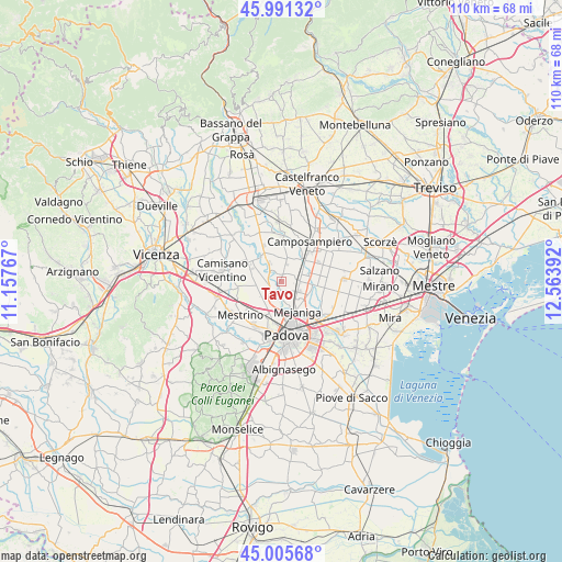
Tavo GPS coordinates[2]
45° 30' 2.376" North, 11° 51' 38.844" East
| Map corner | latitude | longitude |
|---|---|---|
| Upper-left | 45.99132°, | 11.15767° |
| Center: | 45.50066°, | 11.86079° |
| Lower-right: | 45.00568°, | 12.56392° |
| Map W x H: | 109.6×109.6 km | = 68.1×68.1mi |
| max Lat: | 47.04031° ⇑26.3% North |
| Tavo: | 45.50066° |
| min Lat: | ⇓73.7% South 35.50142° |
| min Long | Tavo | max Long |
| 6.69888° | 11.86079° | 18.48682° |
| W 54%⇐ | ⇒46% E |
Elevation
Elevation of Tavo is 17 m = 56 ft, and this is 289.7 m = 950 ft below average elevation for this country.
| Max E: |
2085 m = 6841 ft | 90.6% |
| Avg. | 306.7 m = 1006 ft | |
| Tavo | 17 m = 56 ft | |
Min E: |
-4 m = -13 ft | 9.4% |
See also: Italy elevation on elevation.city.
Geographical zone
Tavo is located in North temperate zone (between Tropic of Cancer and the Arctic Circle). Distance of this North polar circle is 2342 km =1455.3 mi to North.| Distance of | km | miles | from Tavo |
|---|---|---|---|
| North Pole | 4947.9 | 3074.5 | to North |
| Arctic Circle | 2342 | 1455.3 | to North |
| Tropic Cancer | 2453.3 | 1524.4 | to South |
| Equator | 5059.2 | 3143.6 | to South |


Nearby cities:
15 places around Tavo: (largest is in red/bold)
• Campodarsego
4.8 km =3 mi,  93°
93°
• Cavino
2.6 km =1.6 mi,  45°
45°
• Curtarolo
3.2 km =2 mi,  323°
323°
• Limena
3.7 km =2.3 mi,  198°
198°
• Pieve
4.9 km =3 mi,  330°
330°
• Prisco-Sandrin Piccolo
1.6 km =1 mi,  185°
185°
• Saletto
3 km =1.9 mi,  180°
180°
• San Giorgio delle Pertiche
5.2 km =3.2 mi,  29°
29°
• Santa Maria di Non
1.5 km =0.9 mi,  338°
338°
• Taggì
5.5 km =3.4 mi,  216°
216°
• Terraglione
3.3 km =2.1 mi,  123°
123°
• Tremignon
4.8 km =3 mi,  297°
297°
• Vaccarino
2.9 km =1.8 mi,  285°
285°
• Vigodarzere
5.2 km =3.2 mi,  158°
158°
• Villafranca Padovana
5.3 km =3.3 mi,  259°
259°
Sources, notices
• [Note1] Compared only with cities in Italy existing in our database
• [Src1] Map data: © OpenStreetMap contributors (CC-BY-SA)
• [Src2] Other city data from geonames.org with taken over terms of usage.
• [Src3] Geographical zone / Annual Mean Temperature by Robert A. Rohde @ Wikipedia
