Barbara geodata
Barbara (The Marches) is a seat of a third-order administrative division; located in Italy in Europe/Rome (GMT+2) time zone. With population of 953 people, there are 6849 cities with bigger population in this country. Compared to other cities in Italy, 59.1% of cities are located further ↑North; 68.6% of cities are located further ←West and 55.8% of cities have higher elevation than Barbara. Note1


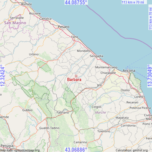
Barbara GPS coordinates[2]
43° 34' 49.296" North, 13° 1' 38.496" East
| Map corner | latitude | longitude |
|---|---|---|
| Upper-left | 44.08755°, | 12.32424° |
| Center: | 43.58036°, | 13.02736° |
| Lower-right: | 43.06886°, | 13.73049° |
| Map W x H: | 113.3×113.3 km | = 70.4×70.4mi |
| max Lat: | 47.04031° ⇑59.1% North |
| Barbara: | 43.58036° |
| min Lat: | ⇓40.9% South 35.50142° |
| min Long | Barbara | max Long |
| 6.69888° | 13.02736° | 18.48682° |
| W 68.6%⇐ | ⇒31.4% E |
Elevation
Elevation of Barbara is 197 m = 646 ft, and this is 109.7 m = 360 ft below average elevation for this country.
| Max E: |
2085 m = 6841 ft | 55.8% |
| Avg. | 306.7 m = 1006 ft | |
| Barbara | 197 m = 646 ft | |
Min E: |
-4 m = -13 ft | 44.2% |
See also: Italy elevation on elevation.city.
Geographical zone
Barbara is located in North temperate zone (between Tropic of Cancer and the Arctic Circle). Distance of this Northern Tropic circle is 2239.8 km =1391.7 mi to South.| Distance of | km | miles | from Barbara |
|---|---|---|---|
| North Pole | 5161.4 | 3207.1 | to North |
| Arctic Circle | 2555.5 | 1587.9 | to North |
| Tropic Cancer | 2239.8 | 1391.7 | to South |
| Equator | 4845.7 | 3011 | to South |


Nearby cities:
15 places around Barbara: (largest is in red/bold)
• Arcevia
11 km =6.8 mi,  217°
217°
• Casine
11 km =6.8 mi,  58°
58°
• Castelleone di Suasa
5 km =3.1 mi,  307°
307°
• Castelplanio
10.5 km =6.5 mi,  155°
155°
• Corinaldo
7.2 km =4.5 mi,  21°
21°
• Montecarotto
6.6 km =4.1 mi,  151°
151°
• Osteria
3.5 km =2.2 mi,  187°
187°
• Ostra
11.3 km =7 mi,  69°
69°
• Ostra Vetere
3.8 km =2.4 mi,  47°
47°
• Passo Ripe
11.3 km =7 mi,  42°
42°
• Pianello
9.8 km =6.1 mi, 58°
• Poggio San Marcello
8.6 km =5.3 mi, 154°
• San Lorenzo in Campo
7.1 km =4.4 mi,  289°
289°
• San Michele
9.4 km =5.8 mi,  345°
345°
• Serra de' Conti
4.3 km =2.7 mi,  171°
171°
Sources, notices
• [Note1] Compared only with cities in Italy existing in our database
• [Src1] Map data: © OpenStreetMap contributors (CC-BY-SA)
• [Src2] Other city data from geonames.org with taken over terms of usage.
• [Src3] Geographical zone / Annual Mean Temperature by Robert A. Rohde @ Wikipedia
