San Lorenzo in Campo geodata
San Lorenzo in Campo (The Marches) is a seat of a third-order administrative division; located in Italy in Europe/Rome (GMT+2) time zone. With population of 2,311 people, there are 3746 cities with bigger population in this country. Compared to other cities in Italy, 59% of cities are located further ↑North; 67.6% of cities are located further ←West and 58.7% of cities have higher elevation than San Lorenzo in Campo. Note1
Administrative division(s):
- Level 1: The Marches
- Level 2: Provincia di Pesaro e Urbino
- Level 3: San Lorenzo in Campo
Current local time in San Lorenzo in Campo:
08:55 PM, WednesdayDifference from your time zone: hours


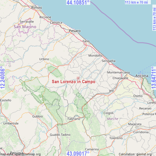
San Lorenzo in Campo GPS coordinates[2]
43° 36' 5.364" North, 12° 56' 38.328" East
| Map corner | latitude | longitude |
|---|---|---|
| Upper-left | 44.10851°, | 12.24086° |
| Center: | 43.60149°, | 12.94398° |
| Lower-right: | 43.09017°, | 13.64711° |
| Map W x H: | 113.2×113.2 km | = 70.3×70.3mi |
| max Lat: | 47.04031° ⇑59% North |
| San Lorenzo in Campo: | 43.60149° |
| min Lat: | ⇓41% South 35.50142° |
| min Long | San Lorenzo in | max Long |
| 6.69888° | 12.94398° | 18.48682° |
| W 67.6%⇐ | ⇒32.4% E |
Elevation
Elevation of San Lorenzo in Campo is 174 m = 571 ft, and this is 132.7 m = 435 ft below average elevation for this country.
| Max E: |
2085 m = 6841 ft | 58.7% |
| Avg. | 306.7 m = 1006 ft | |
| San Lorenzo in Campo | 174 m = 571 ft | |
Min E: |
-4 m = -13 ft | 41.3% |
See also: Italy elevation on elevation.city.
Geographical zone
San Lorenzo in Campo is located in North temperate zone (between Tropic of Cancer and the Arctic Circle). Distance of this Northern Tropic circle is 2242.1 km =1393.2 mi to South.| Distance of | km | miles | from San Lorenzo in Campo |
|---|---|---|---|
| North Pole | 5159 | 3205.7 | to North |
| Arctic Circle | 2553.1 | 1586.4 | to North |
| Tropic Cancer | 2242.1 | 1393.2 | to South |
| Equator | 4848 | 3012.4 | to South |


Nearby cities:
15 places around San Lorenzo in Campo: (largest is in red/bold)
• Arcevia
11.1 km =6.9 mi,  179°
179°
• Barbara
7.1 km =4.4 mi,  109°
109°
• Barchi
8 km =5 mi,  350°
350°
• Castelleone di Suasa
2.8 km =1.7 mi,  74°
74°
• Corinaldo
10.3 km =6.4 mi,  64°
64°
• Fratte Rosa
4.9 km =3 mi,  316°
316°
• Mondavio
8.3 km =5.2 mi,  12°
12°
• Montecarotto
12.8 km =8 mi,  129°
129°
• Orciano di Pesaro
10 km =6.2 mi, 13°
• Osteria
8.5 km =5.3 mi, 132°
• Ostra Vetere
9.5 km =5.9 mi,  88°
88°
• Pergola
10.1 km =6.3 mi,  239°
239°
• San Michele
8 km =5 mi,  32°
32°
• Sant'Ippolito
10.3 km =6.4 mi,  327°
327°
• Serra de' Conti
9.9 km =6.2 mi, 131°
Sources, notices
• [Note1] Compared only with cities in Italy existing in our database
• [Src1] Map data: © OpenStreetMap contributors (CC-BY-SA)
• [Src2] Other city data from geonames.org with taken over terms of usage.
• [Src3] Geographical zone / Annual Mean Temperature by Robert A. Rohde @ Wikipedia
