Montecarotto geodata
Montecarotto (The Marches) is a seat of a third-order administrative division; located in Italy in Europe/Rome (GMT+2) time zone. With population of 1,584 people, there are 4937 cities with bigger population in this country. Compared to other cities in Italy, 59.6% of cities are located further ↑North; 69% of cities are located further ←West and 64.1% of cities have lower elevation than Montecarotto. Note1


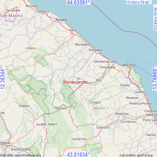
Montecarotto GPS coordinates[2]
43° 31' 41.808" North, 13° 3' 59.616" East
| Map corner | latitude | longitude |
|---|---|---|
| Upper-left | 44.03591°, | 12.36344° |
| Center: | 43.52828°, | 13.06656° |
| Lower-right: | 43.01634°, | 13.76969° |
| Map W x H: | 113.4×113.4 km | = 70.5×70.5mi |
| max Lat: | 47.04031° ⇑59.6% North |
| Montecarotto: | 43.52828° |
| min Lat: | ⇓40.4% South 35.50142° |
| min Long | Montecarotto | max Long |
| 6.69888° | 13.06656° | 18.48682° |
| W 69%⇐ | ⇒31% E |
Elevation
Elevation of Montecarotto is 334 m = 1096 ft, and this is 27.3 m = 90 ft above average elevation for this country.
| Max E: |
2085 m = 6841 ft | 35.9% |
| Montecarotto | 334 m 1096 ft | |
| Avg. | 306.7 m = 1006 ft | |
Min E: |
-4 m = -13 ft | 64.1% |
See also: Italy elevation on elevation.city.
Geographical zone
Montecarotto is located in North temperate zone (between Tropic of Cancer and the Arctic Circle). Distance of this Northern Tropic circle is 2234 km =1388.1 mi to South.| Distance of | km | miles | from Montecarotto |
|---|---|---|---|
| North Pole | 5167.2 | 3210.7 | to North |
| Arctic Circle | 2561.3 | 1591.5 | to North |
| Tropic Cancer | 2234 | 1388.1 | to South |
| Equator | 4839.9 | 3007.4 | to South |


Nearby cities:
15 places around Montecarotto: (largest is in red/bold)
• Angeli
6.2 km =3.9 mi,  178°
178°
• Angeli Stazione
5.4 km =3.4 mi,  168°
168°
• Angeli di Mergo
7.2 km =4.5 mi,  187°
187°
• Barbara
6.6 km =4.1 mi,  331°
331°
• Castelbellino
7.8 km =4.8 mi,  126°
126°
• Castelplanio
4 km =2.5 mi,  162°
162°
• Macine-Borgo Loreto
5 km =3.1 mi, 160°
• Maiolati Spontini
7.2 km =4.5 mi,  143°
143°
• Mergo
6.6 km =4.1 mi,  202°
202°
• Moie
6 km =3.7 mi,  117°
117°
• Osteria
4.3 km =2.7 mi,  303°
303°
• Poggio San Marcello
2 km =1.2 mi, 163°
• Rosora
5 km =3.1 mi, 178°
• Serra de' Conti
2.9 km =1.8 mi, 301°
• Stazione
7.5 km =4.7 mi,  114°
114°
Sources, notices
• [Note1] Compared only with cities in Italy existing in our database
• [Src1] Map data: © OpenStreetMap contributors (CC-BY-SA)
• [Src2] Other city data from geonames.org with taken over terms of usage.
• [Src3] Geographical zone / Annual Mean Temperature by Robert A. Rohde @ Wikipedia
