Tufo geodata
Tufo (Campania) is a seat of a third-order administrative division; located in Italy in Europe/Rome (GMT+2) time zone. With population of 691 people, there are 8358 cities with bigger population in this country. Compared to other cities in Italy, 78.5% of cities are located further ↑North; 85.6% of cities are located further ←West and 51.6% of cities have higher elevation than Tufo. Note1


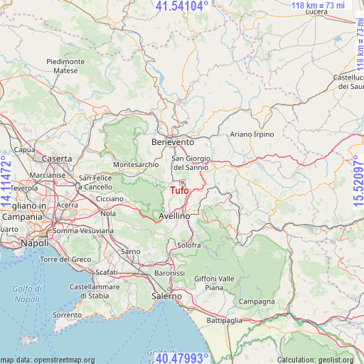
Tufo GPS coordinates[2]
41° 0' 45.432" North, 14° 49' 4.224" East
| Map corner | latitude | longitude |
|---|---|---|
| Upper-left | 41.54104°, | 14.11472° |
| Center: | 41.01262°, | 14.81784° |
| Lower-right: | 40.47993°, | 15.52097° |
| Map W x H: | 118×118 km | = 73.3×73.3mi |
| max Lat: | 47.04031° ⇑78.5% North |
| Tufo: | 41.01262° |
| min Lat: | ⇓21.5% South 35.50142° |
| min Long | Tufo | max Long |
| 6.69888° | 14.81784° | 18.48682° |
| W 85.6%⇐ | ⇒14.4% E |
Elevation
Elevation of Tufo is 224 m = 735 ft, and this is 82.7 m = 271 ft below average elevation for this country.
| Max E: |
2085 m = 6841 ft | 51.6% |
| Avg. | 306.7 m = 1006 ft | |
| Tufo | 224 m = 735 ft | |
Min E: |
-4 m = -13 ft | 48.4% |
See also: Italy elevation on elevation.city.
Geographical zone
Tufo is located in North temperate zone (between Tropic of Cancer and the Arctic Circle). Distance of this Northern Tropic circle is 1954.3 km =1214.3 mi to South.| Distance of | km | miles | from Tufo |
|---|---|---|---|
| North Pole | 5446.9 | 3384.5 | to North |
| Arctic Circle | 2841 | 1765.3 | to North |
| Tropic Cancer | 1954.3 | 1214.3 | to South |
| Equator | 4560.2 | 2833.6 | to South |


Nearby cities:
15 places around Tufo: (largest is in red/bold)
• Altavilla Irpina
3.2 km =2 mi,  257°
257°
• Ceppaloni
6 km =3.7 mi,  307°
307°
• Chianche
4.5 km =2.8 mi,  327°
327°
• Grottolella
5.2 km =3.2 mi,  207°
207°
• Montaperto
6.4 km =4 mi,  96°
96°
• Montefredane
5.9 km =3.7 mi,  183°
183°
• Montefusco
4.1 km =2.5 mi,  49°
49°
• Petruro Irpino
2.7 km =1.7 mi,  321°
321°
• Prata di Principato Ultra
3.4 km =2.1 mi,  149°
149°
• Pratola Serra
4 km =2.5 mi,  135°
135°
• San Giacomo
5.9 km =3.7 mi,  22°
22°
• San Martino Sannita
6 km =3.7 mi,  13°
13°
• San Nazzaro
5.5 km =3.4 mi,  37°
37°
• Santa Paolina
2.6 km =1.6 mi,  66°
66°
• Torrioni
2.4 km =1.5 mi,  351°
351°
Sources, notices
• [Note1] Compared only with cities in Italy existing in our database
• [Src1] Map data: © OpenStreetMap contributors (CC-BY-SA)
• [Src2] Other city data from geonames.org with taken over terms of usage.
• [Src3] Geographical zone / Annual Mean Temperature by Robert A. Rohde @ Wikipedia
