Grottolella geodata
Grottolella (Campania) is a seat of a third-order administrative division; located in Italy in Europe/Rome (GMT+2) time zone. With population of 971 people, there are 6772 cities with bigger population in this country. Compared to other cities in Italy, 78.9% of cities are located further ↑North; 85.4% of cities are located further ←West and 82.9% of cities have lower elevation than Grottolella. Note1


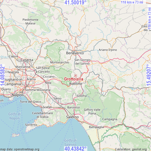
Grottolella GPS coordinates[2]
40° 58' 17.184" North, 14° 47' 20.184" East
| Map corner | latitude | longitude |
|---|---|---|
| Upper-left | 41.50019°, | 14.08582° |
| Center: | 40.97144°, | 14.78894° |
| Lower-right: | 40.43842°, | 15.49207° |
| Map W x H: | 118.1×118.1 km | = 73.4×73.4mi |
| max Lat: | 47.04031° ⇑78.9% North |
| Grottolella: | 40.97144° |
| min Lat: | ⇓21.1% South 35.50142° |
| min Long | Grottolella | max Long |
| 6.69888° | 14.78894° | 18.48682° |
| W 85.4%⇐ | ⇒14.6% E |
Elevation
Elevation of Grottolella is 571 m = 1873 ft, and this is 264.3 m = 867 ft above average elevation for this country.
| Max E: |
2085 m = 6841 ft | 17.1% |
| Grottolella | 571 m 1873 ft | |
| Avg. | 306.7 m = 1006 ft | |
Min E: |
-4 m = -13 ft | 82.9% |
See also: Italy elevation on elevation.city.
Geographical zone
Grottolella is located in North temperate zone (between Tropic of Cancer and the Arctic Circle). Distance of this Northern Tropic circle is 1949.7 km =1211.5 mi to South.| Distance of | km | miles | from Grottolella |
|---|---|---|---|
| North Pole | 5451.5 | 3387.4 | to North |
| Arctic Circle | 2845.6 | 1768.2 | to North |
| Tropic Cancer | 1949.7 | 1211.5 | to South |
| Equator | 4555.6 | 2830.7 | to South |


Nearby cities:
15 places around Grottolella: (largest is in red/bold)
• Altavilla Irpina
3.9 km =2.4 mi,  350°
350°
• Atripalda
6.7 km =4.2 mi,  151°
151°
• Avellino
6.3 km =3.9 mi,  178°
178°
• Capriglia
1.6 km =1 mi,  214°
214°
• Capriglia Irpina
1.6 km =1 mi,  218°
218°
• Manocalzati
5.9 km =3.7 mi,  124°
124°
• Mercogliano
6.7 km =4.2 mi, 213°
• Montefredane
2.5 km =1.6 mi, 121°
• Ospedaletto d'Alpinolo
5.1 km =3.2 mi, 224°
• Pietrastornina
6.5 km =4 mi,  294°
294°
• Prata di Principato Ultra
4.4 km =2.7 mi,  68°
68°
• Pratola Serra
5.5 km =3.4 mi, 72°
• Sant'Angelo A Scala
4.1 km =2.5 mi,  275°
275°
• Summonte
4.5 km =2.8 mi,  235°
235°
• Tufo
5.2 km =3.2 mi,  27°
27°
Sources, notices
• [Note1] Compared only with cities in Italy existing in our database
• [Src1] Map data: © OpenStreetMap contributors (CC-BY-SA)
• [Src2] Other city data from geonames.org with taken over terms of usage.
• [Src3] Geographical zone / Annual Mean Temperature by Robert A. Rohde @ Wikipedia
