Ronago geodata
Ronago (Lombardy) is a seat of a third-order administrative division; located in Italy in Europe/Rome (GMT+2) time zone. With population of 1,251 people, there are 5784 cities with bigger population in this country. Compared to other cities in Italy, 87.1% of cities are located further ↓South; 81.5% of cities are located further →East and 67.9% of cities have lower elevation than Ronago. Note1


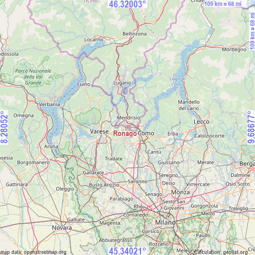
Ronago GPS coordinates[2]
45° 49' 56.208" North, 8° 59' 1.104" East
| Map corner | latitude | longitude |
|---|---|---|
| Upper-left | 46.32003°, | 8.28052° |
| Center: | 45.83228°, | 8.98364° |
| Lower-right: | 45.34021°, | 9.68677° |
| Map W x H: | 108.9×108.9 km | = 67.7×67.7mi |
| max Lat: | 47.04031° ⇑12.9% North |
| Ronago: | 45.83228° |
| min Lat: | ⇓87.1% South 35.50142° |
| min Long | Ronago | max Long |
| 6.69888° | 8.98364° | 18.48682° |
| W 18.5%⇐ | ⇒81.5% E |
Elevation
Elevation of Ronago is 373 m = 1224 ft, and this is 66.3 m = 218 ft above average elevation for this country.
| Max E: |
2085 m = 6841 ft | 32.1% |
| Ronago | 373 m 1224 ft | |
| Avg. | 306.7 m = 1006 ft | |
Min E: |
-4 m = -13 ft | 67.9% |
See also: Italy elevation on elevation.city.
Geographical zone
Ronago is located in North temperate zone (between Tropic of Cancer and the Arctic Circle). Distance of this North polar circle is 2305.1 km =1432.3 mi to North.| Distance of | km | miles | from Ronago |
|---|---|---|---|
| North Pole | 4911 | 3051.6 | to North |
| Arctic Circle | 2305.1 | 1432.3 | to North |
| Tropic Cancer | 2490.2 | 1547.3 | to South |
| Equator | 5096.1 | 3166.6 | to South |


Nearby cities:
15 places around Ronago: (largest is in red/bold)
• Albiolo
4.5 km =2.8 mi,  229°
229°
• Bizzarone
3.2 km =2 mi,  274°
274°
• Camnago-Boscone
3.1 km =1.9 mi,  186°
186°
• Cavallasca
4.6 km =2.9 mi,  123°
123°
• Clivio
5.3 km =3.3 mi,  309°
309°
• Drezzo
2.1 km =1.3 mi,  155°
155°
• Faloppio
2.9 km =1.8 mi,  210°
210°
• Gaggino
3.1 km =1.9 mi, 208°
• Gironico al Piano
3.8 km =2.4 mi, 156°
• Maslianico
5.2 km =3.2 mi,  76°
76°
• Montano
5.2 km =3.2 mi,  144°
144°
• Parè
3.1 km =1.9 mi, 140°
• Rodero
5.4 km =3.4 mi,  260°
260°
• Uggiate Trevano
2.1 km =1.3 mi,  241°
241°
• Valmorea
4.5 km =2.8 mi,  245°
245°
Sources, notices
• [Note1] Compared only with cities in Italy existing in our database
• [Src1] Map data: © OpenStreetMap contributors (CC-BY-SA)
• [Src2] Other city data from geonames.org with taken over terms of usage.
• [Src3] Geographical zone / Annual Mean Temperature by Robert A. Rohde @ Wikipedia
