Sorico geodata
Sorico (Lombardy) is a seat of a third-order administrative division; located in Italy in Europe/Rome (GMT+2) time zone. With population of 599 people, there are 9016 cities with bigger population in this country. Compared to other cities in Italy, 95.6% of cities are located further ↓South; 74.8% of cities are located further →East and 54.3% of cities have higher elevation than Sorico. Note1


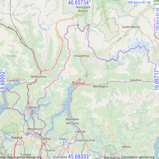
Sorico GPS coordinates[2]
46° 10' 21.324" North, 9° 23' 2.544" East
| Map corner | latitude | longitude |
|---|---|---|
| Upper-left | 46.65734°, | 8.68092° |
| Center: | 46.17259°, | 9.38404° |
| Lower-right: | 45.68353°, | 10.08717° |
| Map W x H: | 108.3×108.3 km | = 67.3×67.3mi |
| max Lat: | 47.04031° ⇑4.4% North |
| Sorico: | 46.17259° |
| min Lat: | ⇓95.6% South 35.50142° |
| min Long | Sorico | max Long |
| 6.69888° | 9.38404° | 18.48682° |
| W 25.2%⇐ | ⇒74.8% E |
Elevation
Elevation of Sorico is 207 m = 679 ft, and this is 99.7 m = 327 ft below average elevation for this country.
| Max E: |
2085 m = 6841 ft | 54.3% |
| Avg. | 306.7 m = 1006 ft | |
| Sorico | 207 m = 679 ft | |
Min E: |
-4 m = -13 ft | 45.7% |
See also: Italy elevation on elevation.city.
Geographical zone
Sorico is located in North temperate zone (between Tropic of Cancer and the Arctic Circle). Distance of this North polar circle is 2267.3 km =1408.8 mi to North.| Distance of | km | miles | from Sorico |
|---|---|---|---|
| North Pole | 4873.2 | 3028.1 | to North |
| Arctic Circle | 2267.3 | 1408.8 | to North |
| Tropic Cancer | 2528 | 1570.8 | to South |
| Equator | 5133.9 | 3190.1 | to South |


Nearby cities:
15 places around Sorico: (largest is in red/bold)
• Aurogna
2.2 km =1.4 mi,  266°
266°
• Colico Piano
4.5 km =2.8 mi,  186°
186°
• Delebio
7.2 km =4.5 mi,  123°
123°
• Domaso
4.6 km =2.9 mi,  241°
241°
• Dubino
3.6 km =2.2 mi,  99°
99°
• Gera Lario
1.3 km =0.8 mi,  257°
257°
• Gravedona-San Gregorio
7 km =4.3 mi,  245°
245°
• Livo
6.2 km =3.9 mi, 265°
• Montemezzo
1.2 km =0.7 mi,  304°
304°
• Novate Mezzola
7.3 km =4.5 mi,  44°
44°
• Peglio
7 km =4.3 mi, 258°
• Piantedo
5.2 km =3.2 mi,  139°
139°
• Trezzone
2.5 km =1.6 mi, 267°
• Vercana
4 km =2.5 mi, 248°
• Verceia
6.2 km =3.9 mi,  61°
61°
Sources, notices
• [Note1] Compared only with cities in Italy existing in our database
• [Src1] Map data: © OpenStreetMap contributors (CC-BY-SA)
• [Src2] Other city data from geonames.org with taken over terms of usage.
• [Src3] Geographical zone / Annual Mean Temperature by Robert A. Rohde @ Wikipedia
