Dubino geodata
Dubino (Lombardy) is a seat of a third-order administrative division; located in Italy in Europe/Rome (GMT+2) time zone. With population of 3,418 people, there are 2742 cities with bigger population in this country. Compared to other cities in Italy, 95.5% of cities are located further ↓South; 74.1% of cities are located further →East and 55.1% of cities have higher elevation than Dubino. Note1


Dubino GPS coordinates[2]
46° 10' 1.38" North, 9° 25' 49.764" East
| Map corner | latitude | longitude |
|---|---|---|
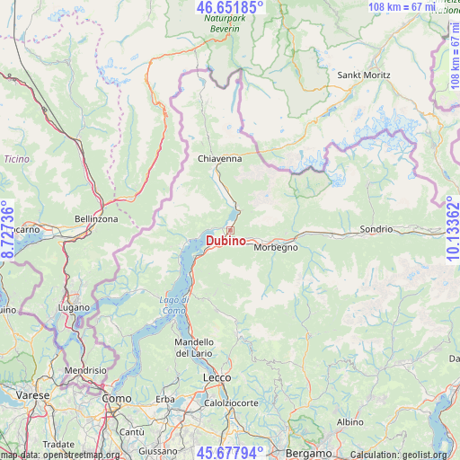
| Upper-left | 46.65185°, | 8.72736° |
| Center: | 46.16705°, | 9.43049° |
| Lower-right: | 45.67794°, | 10.13362° |
| Map W x H: | 108.3×108.3 km | = 67.3×67.3mi |
| max Lat: | 47.04031° ⇑4.5% North |
| Dubino: | 46.16705° |
| min Lat: | ⇓95.5% South 35.50142° |
| min Long | Dubino | max Long |
| 6.69888° | 9.43049° | 18.48682° |
| W 25.9%⇐ | ⇒74.1% E |
Elevation
Elevation of Dubino is 202 m = 663 ft, and this is 104.7 m = 344 ft below average elevation for this country.
| Max E: |
2085 m = 6841 ft | 55.1% |
| Avg. | 306.7 m = 1006 ft | |
| Dubino | 202 m = 663 ft | |
Min E: |
-4 m = -13 ft | 44.9% |
See also: Italy elevation on elevation.city.
Geographical zone
Dubino is located in North temperate zone (between Tropic of Cancer and the Arctic Circle). Distance of this North polar circle is 2267.9 km =1409.2 mi to North.| Distance of | km | miles | from Dubino |
|---|---|---|---|
| North Pole | 4873.8 | 3028.4 | to North |
| Arctic Circle | 2267.9 | 1409.2 | to North |
| Tropic Cancer | 2527.4 | 1570.5 | to South |
| Equator | 5133.3 | 3189.7 | to South |


Nearby cities:
15 places around Dubino: (largest is in red/bold)
• Andalo Valtellino
4.8 km =3 mi,  135°
135°
• Aurogna
5.8 km =3.6 mi,  274°
274°
• Cercino
6.1 km =3.8 mi,  99°
99°
• Cino
4.3 km =2.7 mi, 102°
• Colico Piano
5.7 km =3.5 mi,  226°
226°
• Delebio
4.2 km =2.6 mi, 144°
• Gera Lario
4.9 km =3 mi, 273°
• Mantello
4.8 km =3 mi,  109°
109°
• Montemezzo
4.8 km =3 mi,  285°
285°
• Novate Mezzola
6 km =3.7 mi,  14°
14°
• Piantedo
3.4 km =2.1 mi,  183°
183°
• Piussogno
6.1 km =3.8 mi, 106°
• Rogolo
5.4 km =3.4 mi,  128°
128°
• Sorico
3.6 km =2.2 mi,  279°
279°
• Verceia
4 km =2.5 mi,  27°
27°
Sources, notices
• [Note1] Compared only with cities in Italy existing in our database
• [Src1] Map data: © OpenStreetMap contributors (CC-BY-SA)
• [Src2] Other city data from geonames.org with taken over terms of usage.
• [Src3] Geographical zone / Annual Mean Temperature by Robert A. Rohde @ Wikipedia
