Lisiera geodata
Lisiera (Veneto) is a section of populated place; located in Italy in Europe/Rome (GMT+2) time zone. With population of 1,172 people, there are 6051 cities with bigger population in this country. Compared to other cities in Italy, 76.2% of cities are located further ↓South; 50.7% of cities are located further ←West and 83.4% of cities have higher elevation than Lisiera. Note1
Administrative division(s):
- Level 1: Veneto
- Level 2: Provincia di Vicenza
- Level 3: Bolzano Vicentino


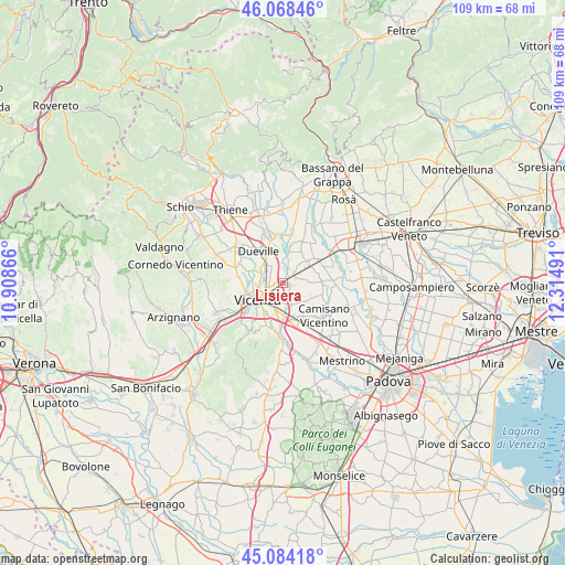
Lisiera GPS coordinates[2]
45° 34' 42.528" North, 11° 36' 42.408" East
| Map corner | latitude | longitude |
|---|---|---|
| Upper-left | 46.06846°, | 10.90866° |
| Center: | 45.57848°, | 11.61178° |
| Lower-right: | 45.08418°, | 12.31491° |
| Map W x H: | 109.4×109.4 km | = 68×68mi |
| max Lat: | 47.04031° ⇑23.8% North |
| Lisiera: | 45.57848° |
| min Lat: | ⇓76.2% South 35.50142° |
| min Long | Lisiera | max Long |
| 6.69888° | 11.61178° | 18.48682° |
| W 50.7%⇐ | ⇒49.3% E |
Elevation
Elevation of Lisiera is 36 m = 118 ft, and this is 270.7 m = 888 ft below average elevation for this country.
| Max E: |
2085 m = 6841 ft | 83.4% |
| Avg. | 306.7 m = 1006 ft | |
| Lisiera | 36 m = 118 ft | |
Min E: |
-4 m = -13 ft | 16.6% |
See also: Italy elevation on elevation.city.
Geographical zone
Lisiera is located in North temperate zone (between Tropic of Cancer and the Arctic Circle). Distance of this North polar circle is 2333.3 km =1449.8 mi to North.| Distance of | km | miles | from Lisiera |
|---|---|---|---|
| North Pole | 4939.2 | 3069.1 | to North |
| Arctic Circle | 2333.3 | 1449.8 | to North |
| Tropic Cancer | 2461.9 | 1529.8 | to South |
| Equator | 5067.9 | 3149 | to South |


Nearby cities:
15 places around Lisiera: (largest is in red/bold)
• Bolzano Vicentino
2.8 km =1.7 mi,  16°
16°
• Gazzo
7.4 km =4.6 mi,  86°
86°
• Lanzè
3.9 km =2.4 mi,  77°
77°
• Marola
4.4 km =2.7 mi,  165°
165°
• Monticello Conte Otto
3.7 km =2.3 mi,  305°
305°
• Poianella
5.9 km =3.7 mi,  12°
12°
• Quinto Vicentino
1.3 km =0.8 mi,  105°
105°
• Rampazzo
7.2 km =4.5 mi,  128°
128°
• San Pietro in Gu
5.9 km =3.7 mi,  54°
54°
• Torri di Quartesolo
6.7 km =4.2 mi, 171°
• Valproto
3.5 km =2.2 mi, 129°
• Vicenza
6.1 km =3.8 mi,  234°
234°
• Vigardolo
3.6 km =2.2 mi,  329°
329°
• Villaggio Montegrappa
3.6 km =2.2 mi,  176°
176°
• Villalta
5.3 km =3.3 mi, 91°
Sources, notices
• [Note1] Compared only with cities in Italy existing in our database
• [Src1] Map data: © OpenStreetMap contributors (CC-BY-SA)
• [Src2] Other city data from geonames.org with taken over terms of usage.
• [Src3] Geographical zone / Annual Mean Temperature by Robert A. Rohde @ Wikipedia
