Lanzè geodata
Lanzè (Veneto) is a populated place; located in Italy in Europe/Rome (GMT+2) time zone. With population of 764 people, there are 7855 cities with bigger population in this country. Compared to other cities in Italy, 76.5% of cities are located further ↓South; 51.3% of cities are located further ←West and 83.4% of cities have higher elevation than Lanzè. Note1


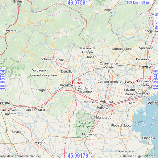
Lanzè GPS coordinates[2]
45° 35' 9.564" North, 11° 39' 39.456" East
| Map corner | latitude | longitude |
|---|---|---|
| Upper-left | 46.07591°, | 10.95784° |
| Center: | 45.58599°, | 11.66096° |
| Lower-right: | 45.09176°, | 12.36409° |
| Map W x H: | 109.4×109.4 km | = 68×68mi |
| max Lat: | 47.04031° ⇑23.5% North |
| Lanzè: | 45.58599° |
| min Lat: | ⇓76.5% South 35.50142° |
| min Long | Lanzè | max Long |
| 6.69888° | 11.66096° | 18.48682° |
| W 51.3%⇐ | ⇒48.7% E |
Elevation
Elevation of Lanzè is 36 m = 118 ft, and this is 270.7 m = 888 ft below average elevation for this country.
| Max E: |
2085 m = 6841 ft | 83.4% |
| Avg. | 306.7 m = 1006 ft | |
| Lanzè | 36 m = 118 ft | |
Min E: |
-4 m = -13 ft | 16.6% |
See also: Italy elevation on elevation.city.
Geographical zone
Lanzè is located in North temperate zone (between Tropic of Cancer and the Arctic Circle). Distance of this North polar circle is 2332.5 km =1449.3 mi to North.| Distance of | km | miles | from Lanzè |
|---|---|---|---|
| North Pole | 4938.4 | 3068.6 | to North |
| Arctic Circle | 2332.5 | 1449.3 | to North |
| Tropic Cancer | 2462.8 | 1530.3 | to South |
| Equator | 5068.7 | 3149.5 | to South |


Nearby cities:
15 places around Lanzè: (largest is in red/bold)
• Bolzano Vicentino
3.5 km =2.2 mi,  300°
300°
• Carmignano di Brenta
5.6 km =3.5 mi,  38°
38°
• Gazzo
3.6 km =2.2 mi,  96°
96°
• Grantorto
5.8 km =3.6 mi,  71°
71°
• Grossa
4.6 km =2.9 mi,  131°
131°
• Lisiera
3.9 km =2.4 mi,  257°
257°
• Marola
5.8 km =3.6 mi,  208°
208°
• Poianella
5.5 km =3.4 mi,  332°
332°
• Quinto Vicentino
2.8 km =1.7 mi,  245°
245°
• Rampazzo
5.6 km =3.5 mi,  160°
160°
• San Pietro in Gu
2.7 km =1.7 mi,  21°
21°
• Valproto
3.3 km =2.1 mi,  200°
200°
• Vigardolo
6.1 km =3.8 mi,  291°
291°
• Villaggio Montegrappa
5.7 km =3.5 mi,  219°
219°
• Villalta
1.8 km =1.1 mi,  122°
122°
Sources, notices
• [Note1] Compared only with cities in Italy existing in our database
• [Src1] Map data: © OpenStreetMap contributors (CC-BY-SA)
• [Src2] Other city data from geonames.org with taken over terms of usage.
• [Src3] Geographical zone / Annual Mean Temperature by Robert A. Rohde @ Wikipedia
