Trodica geodata
Trodica (The Marches) is a populated place; located in Italy in Europe/Rome (GMT+2) time zone. With population of 4,397 people, there are 2191 cities with bigger population in this country. Compared to other cities in Italy, 61.3% of cities are located further ↑North; 74.6% of cities are located further ←West and 78.8% of cities have higher elevation than Trodica. Note1


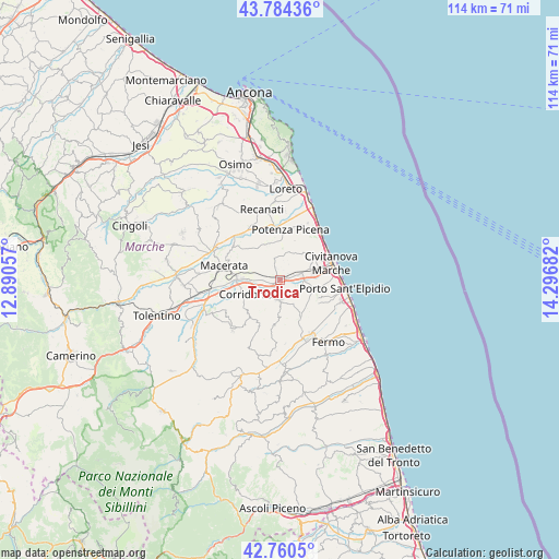
Trodica GPS coordinates[2]
43° 16' 28.488" North, 13° 35' 37.284" East
| Map corner | latitude | longitude |
|---|---|---|
| Upper-left | 43.78436°, | 12.89057° |
| Center: | 43.27458°, | 13.59369° |
| Lower-right: | 42.7605°, | 14.29682° |
| Map W x H: | 113.8×113.8 km | = 70.7×70.7mi |
| max Lat: | 47.04031° ⇑61.3% North |
| Trodica: | 43.27458° |
| min Lat: | ⇓38.7% South 35.50142° |
| min Long | Trodica | max Long |
| 6.69888° | 13.59369° | 18.48682° |
| W 74.6%⇐ | ⇒25.4% E |
Elevation
Elevation of Trodica is 55 m = 180 ft, and this is 251.7 m = 826 ft below average elevation for this country.
| Max E: |
2085 m = 6841 ft | 78.8% |
| Avg. | 306.7 m = 1006 ft | |
| Trodica | 55 m = 180 ft | |
Min E: |
-4 m = -13 ft | 21.2% |
See also: Italy elevation on elevation.city.
Geographical zone
Trodica is located in North temperate zone (between Tropic of Cancer and the Arctic Circle). Distance of this Northern Tropic circle is 2205.8 km =1370.6 mi to South.| Distance of | km | miles | from Trodica |
|---|---|---|---|
| North Pole | 5195.4 | 3228.3 | to North |
| Arctic Circle | 2589.5 | 1609 | to North |
| Tropic Cancer | 2205.8 | 1370.6 | to South |
| Equator | 4811.7 | 2989.9 | to South |


Nearby cities:
15 places around Trodica: (largest is in red/bold)
• Borgo Stazione
4.2 km =2.6 mi,  74°
74°
• Casette d'Ete
7.6 km =4.7 mi,  107°
107°
• Civitanova Alta
8.4 km =5.2 mi,  56°
56°
• Corridonia
7.7 km =4.8 mi,  246°
246°
• Monte San Giusto
4.3 km =2.7 mi,  180°
180°
• Montecosaro
5.8 km =3.6 mi,  37°
37°
• Montegranaro
5.7 km =3.5 mi,  148°
148°
• Montelupone
7.8 km =4.8 mi,  346°
346°
• Morrovalle
4.9 km =3 mi,  1°
1°
• Pintura
3.6 km =2.2 mi,  343°
343°
• San Claudio
7.4 km =4.6 mi,  270°
270°
• Santa Maria Apparente
8.3 km =5.2 mi, 72°
• Stazione Morrovalle
0.9 km =0.6 mi,  324°
324°
• Vagli
3.7 km =2.3 mi,  115°
115°
• Villa San Filippo
1.6 km =1 mi, 180°
Sources, notices
• [Note1] Compared only with cities in Italy existing in our database
• [Src1] Map data: © OpenStreetMap contributors (CC-BY-SA)
• [Src2] Other city data from geonames.org with taken over terms of usage.
• [Src3] Geographical zone / Annual Mean Temperature by Robert A. Rohde @ Wikipedia
