San Claudio geodata
San Claudio (The Marches) is a populated place; located in Italy in Europe/Rome (GMT+2) time zone. With population of 965 people, there are 6799 cities with bigger population in this country. Compared to other cities in Italy, 61.3% of cities are located further ↑North; 73.7% of cities are located further ←West and 71.5% of cities have higher elevation than San Claudio. Note1


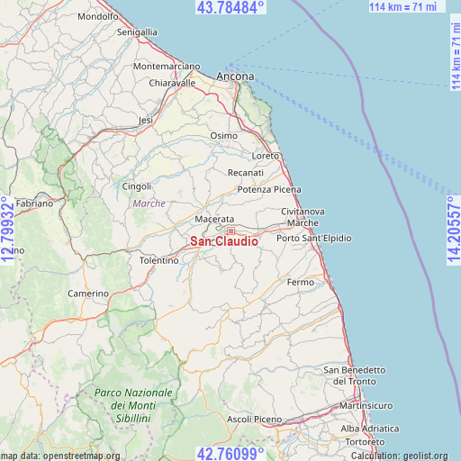
San Claudio GPS coordinates[2]
43° 16' 30.252" North, 13° 30' 8.784" East
| Map corner | latitude | longitude |
|---|---|---|
| Upper-left | 43.78484°, | 12.79932° |
| Center: | 43.27507°, | 13.50244° |
| Lower-right: | 42.76099°, | 14.20557° |
| Map W x H: | 113.8×113.8 km | = 70.7×70.7mi |
| max Lat: | 47.04031° ⇑61.3% North |
| San Claudio: | 43.27507° |
| min Lat: | ⇓38.7% South 35.50142° |
| min Long | San Claudio | max Long |
| 6.69888° | 13.50244° | 18.48682° |
| W 73.7%⇐ | ⇒26.3% E |
Elevation
Elevation of San Claudio is 90 m = 295 ft, and this is 216.7 m = 711 ft below average elevation for this country.
| Max E: |
2085 m = 6841 ft | 71.5% |
| Avg. | 306.7 m = 1006 ft | |
| San Claudio | 90 m = 295 ft | |
Min E: |
-4 m = -13 ft | 28.5% |
See also: Italy elevation on elevation.city.
Geographical zone
San Claudio is located in North temperate zone (between Tropic of Cancer and the Arctic Circle). Distance of this Northern Tropic circle is 2205.8 km =1370.6 mi to South.| Distance of | km | miles | from San Claudio |
|---|---|---|---|
| North Pole | 5195.3 | 3228.2 | to North |
| Arctic Circle | 2589.4 | 1609 | to North |
| Tropic Cancer | 2205.8 | 1370.6 | to South |
| Equator | 4811.7 | 2989.9 | to South |


Nearby cities:
15 places around San Claudio: (largest is in red/bold)
• Casette Verdini
8.6 km =5.3 mi,  251°
251°
• Corridonia
3.2 km =2 mi,  173°
173°
• Macerata
4.7 km =2.9 mi,  302°
302°
• Monte San Giusto
8.6 km =5.3 mi,  120°
120°
• Passo del Bidollo
7 km =4.3 mi, 245°
• Petriolo
6.8 km =4.2 mi,  208°
208°
• Piediripa
1.3 km =0.8 mi,  282°
282°
• Pintura
7.2 km =4.5 mi,  62°
62°
• Sant'Egidio
8.8 km =5.5 mi,  335°
335°
• Sforzacosta
6.8 km =4.2 mi, 252°
• Stazione Morrovalle
6.9 km =4.3 mi,  84°
84°
• Trodica
7.4 km =4.6 mi,  90°
90°
• Villa Potenza
8 km =5 mi,  310°
310°
• Villa San Filippo
7.6 km =4.7 mi,  102°
102°
• Zona Industriale
1.9 km =1.2 mi,  217°
217°
Sources, notices
• [Note1] Compared only with cities in Italy existing in our database
• [Src1] Map data: © OpenStreetMap contributors (CC-BY-SA)
• [Src2] Other city data from geonames.org with taken over terms of usage.
• [Src3] Geographical zone / Annual Mean Temperature by Robert A. Rohde @ Wikipedia
