Rosà geodata
Rosà (Veneto) is a seat of a third-order administrative division; located in Italy in Europe/Rome (GMT+2) time zone. With population of 12,548 people, there are 743 cities with bigger population in this country. Compared to other cities in Italy, 81.2% of cities are located further ↓South; 52.6% of cities are located further ←West and 74.5% of cities have higher elevation than Rosà. Note1


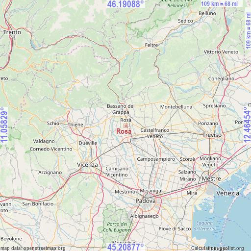
Rosà GPS coordinates[2]
45° 42' 7.128" North, 11° 45' 41.076" East
| Map corner | latitude | longitude |
|---|---|---|
| Upper-left | 46.19088°, | 11.05829° |
| Center: | 45.70198°, | 11.76141° |
| Lower-right: | 45.20877°, | 12.46454° |
| Map W x H: | 109.2×109.2 km | = 67.9×67.9mi |
| max Lat: | 47.04031° ⇑18.8% North |
| Rosà: | 45.70198° |
| min Lat: | ⇓81.2% South 35.50142° |
| min Long | Rosà | max Long |
| 6.69888° | 11.76141° | 18.48682° |
| W 52.6%⇐ | ⇒47.4% E |
Elevation
Elevation of Rosà is 76 m = 249 ft, and this is 230.7 m = 757 ft below average elevation for this country.
| Max E: |
2085 m = 6841 ft | 74.5% |
| Avg. | 306.7 m = 1006 ft | |
| Rosà | 76 m = 249 ft | |
Min E: |
-4 m = -13 ft | 25.5% |
See also: Italy elevation on elevation.city.
Geographical zone
Rosà is located in North temperate zone (between Tropic of Cancer and the Arctic Circle). Distance of this North polar circle is 2319.6 km =1441.3 mi to North.| Distance of | km | miles | from Rosà |
|---|---|---|---|
| North Pole | 4925.5 | 3060.6 | to North |
| Arctic Circle | 2319.6 | 1441.3 | to North |
| Tropic Cancer | 2475.7 | 1538.3 | to South |
| Equator | 5081.6 | 3157.6 | to South |


Nearby cities:
15 places around Rosà: (largest is in red/bold)
• Alberone
6.8 km =4.2 mi,  101°
101°
• Belvedere
1.6 km =1 mi,  148°
148°
• Ca' Onorai
4.5 km =2.8 mi,  138°
138°
• Cartigliano
5.3 km =3.3 mi,  283°
283°
• Cassola
4.6 km =2.9 mi,  39°
39°
• Cittadella
6.6 km =4.1 mi,  164°
164°
• Friola
7 km =4.3 mi,  247°
247°
• Galliera Veneta
6.1 km =3.8 mi,  129°
129°
• Nove
6.8 km =4.2 mi,  288°
288°
• Ramon-Campagna
5.9 km =3.7 mi,  80°
80°
• Rossano Veneto
3.3 km =2.1 mi,  87°
87°
• Sacro Cuore
6 km =3.7 mi,  26°
26°
• San Zeno-San Giuseppe
6.1 km =3.8 mi,  0°
0°
• Santa Croce Bigolina
5.2 km =3.2 mi,  219°
219°
• Tezze
4.4 km =2.7 mi, 252°
Sources, notices
• [Note1] Compared only with cities in Italy existing in our database
• [Src1] Map data: © OpenStreetMap contributors (CC-BY-SA)
• [Src2] Other city data from geonames.org with taken over terms of usage.
• [Src3] Geographical zone / Annual Mean Temperature by Robert A. Rohde @ Wikipedia
