Cassola geodata
Cassola (Veneto) is a seat of a third-order administrative division; located in Italy in Europe/Rome (GMT+2) time zone. With population of 3,825 people, there are 2494 cities with bigger population in this country. Compared to other cities in Italy, 82.8% of cities are located further ↓South; 53.1% of cities are located further ←West and 71.3% of cities have higher elevation than Cassola. Note1


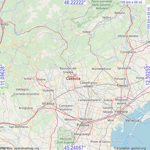
Cassola GPS coordinates[2]
45° 44' 0.96" North, 11° 47' 57.84" East
| Map corner | latitude | longitude |
|---|---|---|
| Upper-left | 46.22222°, | 11.09628° |
| Center: | 45.7336°, | 11.7994° |
| Lower-right: | 45.24067°, | 12.50253° |
| Map W x H: | 109.1×109.1 km | = 67.8×67.8mi |
| max Lat: | 47.04031° ⇑17.2% North |
| Cassola: | 45.7336° |
| min Lat: | ⇓82.8% South 35.50142° |
| min Long | Cassola | max Long |
| 6.69888° | 11.7994° | 18.48682° |
| W 53.1%⇐ | ⇒46.9% E |
Elevation
Elevation of Cassola is 91 m = 299 ft, and this is 215.7 m = 708 ft below average elevation for this country.
| Max E: |
2085 m = 6841 ft | 71.3% |
| Avg. | 306.7 m = 1006 ft | |
| Cassola | 91 m = 299 ft | |
Min E: |
-4 m = -13 ft | 28.7% |
See also: Italy elevation on elevation.city.
Geographical zone
Cassola is located in North temperate zone (between Tropic of Cancer and the Arctic Circle). Distance of this North polar circle is 2316.1 km =1439.2 mi to North.| Distance of | km | miles | from Cassola |
|---|---|---|---|
| North Pole | 4922 | 3058.4 | to North |
| Arctic Circle | 2316.1 | 1439.2 | to North |
| Tropic Cancer | 2479.2 | 1540.5 | to South |
| Equator | 5085.1 | 3159.7 | to South |


Nearby cities:
15 places around Cassola: (largest is in red/bold)
• Alberone
6.1 km =3.8 mi,  142°
142°
• Belvedere
5.3 km =3.3 mi,  203°
203°
• Ca' Rainati
4.8 km =3 mi,  56°
56°
• Casoni
3 km =1.9 mi,  16°
16°
• Loria Bessica
5.1 km =3.2 mi,  94°
94°
• Mussolente
5.1 km =3.2 mi,  5°
5°
• Ramon
5.8 km =3.6 mi,  112°
112°
• Ramon-Campagna
3.8 km =2.4 mi,  132°
132°
• Romano d'Ezzelino
5.7 km =3.5 mi,  333°
333°
• Rossano Veneto
3.4 km =2.1 mi,  174°
174°
• Rosà
4.6 km =2.9 mi,  219°
219°
• Sacro Cuore
1.9 km =1.2 mi,  351°
351°
• San Zeno-San Giuseppe
3.9 km =2.4 mi,  312°
312°
• San Zenone degli Ezzelini
6 km =3.7 mi,  29°
29°
• Spineda
6.4 km =4 mi,  73°
73°
Sources, notices
• [Note1] Compared only with cities in Italy existing in our database
• [Src1] Map data: © OpenStreetMap contributors (CC-BY-SA)
• [Src2] Other city data from geonames.org with taken over terms of usage.
• [Src3] Geographical zone / Annual Mean Temperature by Robert A. Rohde @ Wikipedia
