Spineda geodata
Spineda (Veneto) is a populated place; located in Italy in Europe/Rome (GMT+2) time zone. With population of 881 people, there are 7265 cities with bigger population in this country. Compared to other cities in Italy, 83.6% of cities are located further ↓South; 54.2% of cities are located further ←West and 75.4% of cities have higher elevation than Spineda. Note1


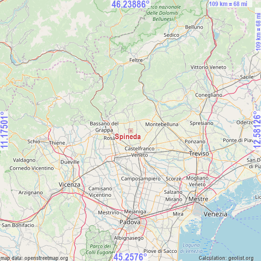
Spineda GPS coordinates[2]
45° 45' 1.404" North, 11° 52' 41.268" East
| Map corner | latitude | longitude |
|---|---|---|
| Upper-left | 46.23886°, | 11.17501° |
| Center: | 45.75039°, | 11.87813° |
| Lower-right: | 45.2576°, | 12.58126° |
| Map W x H: | 109.1×109.1 km | = 67.8×67.8mi |
| max Lat: | 47.04031° ⇑16.4% North |
| Spineda: | 45.75039° |
| min Lat: | ⇓83.6% South 35.50142° |
| min Long | Spineda | max Long |
| 6.69888° | 11.87813° | 18.48682° |
| W 54.2%⇐ | ⇒45.8% E |
Elevation
Elevation of Spineda is 72 m = 236 ft, and this is 234.7 m = 770 ft below average elevation for this country.
| Max E: |
2085 m = 6841 ft | 75.4% |
| Avg. | 306.7 m = 1006 ft | |
| Spineda | 72 m = 236 ft | |
Min E: |
-4 m = -13 ft | 24.6% |
See also: Italy elevation on elevation.city.
Geographical zone
Spineda is located in North temperate zone (between Tropic of Cancer and the Arctic Circle). Distance of this North polar circle is 2314.2 km =1438 mi to North.| Distance of | km | miles | from Spineda |
|---|---|---|---|
| North Pole | 4920.1 | 3057.2 | to North |
| Arctic Circle | 2314.2 | 1438 | to North |
| Tropic Cancer | 2481 | 1541.6 | to South |
| Equator | 5087 | 3160.9 | to South |


Nearby cities:
15 places around Spineda: (largest is in red/bold)
• Altivole
6.1 km =3.8 mi,  86°
86°
• Asolo
5.2 km =3.2 mi,  35°
35°
• Ca' Rainati
2.2 km =1.4 mi,  291°
291°
• Casoni
5.3 km =3.3 mi,  280°
280°
• Fonte Alto
5.9 km =3.7 mi,  347°
347°
• Loria Bessica
2.5 km =1.6 mi,  203°
203°
• Onè
3.7 km =2.3 mi,  355°
355°
• Poggiana
3.5 km =2.2 mi,  175°
175°
• Ramon
4.1 km =2.5 mi,  190°
190°
• Ramon-Campagna
5.5 km =3.4 mi,  216°
216°
• Riese Pio X
3.9 km =2.4 mi,  128°
128°
• San Vito
2.9 km =1.8 mi,  79°
79°
• San Zenone degli Ezzelini
4.6 km =2.9 mi,  316°
316°
• Vallà
6.4 km =4 mi,  138°
138°
• Villa d'Asolo
2.9 km =1.8 mi, 35°
Sources, notices
• [Note1] Compared only with cities in Italy existing in our database
• [Src1] Map data: © OpenStreetMap contributors (CC-BY-SA)
• [Src2] Other city data from geonames.org with taken over terms of usage.
• [Src3] Geographical zone / Annual Mean Temperature by Robert A. Rohde @ Wikipedia
