Brognoligo-Costalunga geodata
Brognoligo-Costalunga (Veneto) is a populated place; located in Italy in Europe/Rome (GMT+2) time zone. With population of 2,777 people, there are 3240 cities with bigger population in this country. Compared to other cities in Italy, 71.9% of cities are located further ↓South; 53.2% of cities are located further →East and 82% of cities have higher elevation than Brognoligo-Costalunga. Note1
Administrative division(s):
- Level 1: Veneto
- Level 2: Provincia di Verona
- Level 3: Monteforte d'Alpone
Current local time in Brognoligo-Costalunga:
09:32 PM, WednesdayDifference from your time zone: hours


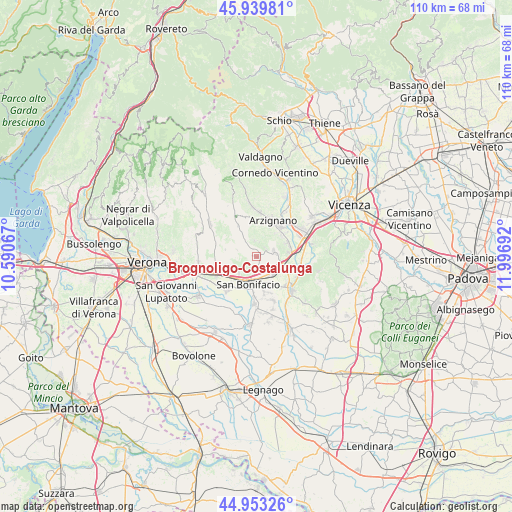
Brognoligo-Costalunga GPS coordinates[2]
45° 26' 55.284" North, 11° 17' 37.644" East
| Map corner | latitude | longitude |
|---|---|---|
| Upper-left | 45.93981°, | 10.59067° |
| Center: | 45.44869°, | 11.29379° |
| Lower-right: | 44.95326°, | 11.99692° |
| Map W x H: | 109.7×109.7 km | = 68.2×68.2mi |
| max Lat: | 47.04031° ⇑28.1% North |
| Brognoligo-Costalunga: | 45.44869° |
| min Lat: | ⇓71.9% South 35.50142° |
| min Long | Brognoligo-Cost | max Long |
| 6.69888° | 11.29379° | 18.48682° |
| W 46.8%⇐ | ⇒53.2% E |
Elevation
Elevation of Brognoligo-Costalunga is 42 m = 138 ft, and this is 264.7 m = 868 ft below average elevation for this country.
| Max E: |
2085 m = 6841 ft | 82% |
| Avg. | 306.7 m = 1006 ft | |
| Brognoligo-Costalunga | 42 m = 138 ft | |
Min E: |
-4 m = -13 ft | 18% |
See also: Italy elevation on elevation.city.
Geographical zone
Brognoligo-Costalunga is located in North temperate zone (between Tropic of Cancer and the Arctic Circle). Distance of this North polar circle is 2347.8 km =1458.9 mi to North.| Distance of | km | miles | from Brognoligo-Costalunga |
|---|---|---|---|
| North Pole | 4953.6 | 3078 | to North |
| Arctic Circle | 2347.8 | 1458.9 | to North |
| Tropic Cancer | 2447.5 | 1520.8 | to South |
| Equator | 5053.4 | 3140 | to South |


Nearby cities:
15 places around Brognoligo-Costalunga: (largest is in red/bold)
• Cazzano di Tramigna
7.6 km =4.7 mi,  290°
290°
• Gambellara
3.8 km =2.4 mi,  71°
71°
• Locara
5.1 km =3.2 mi,  143°
143°
• Montebello Vicentino
7 km =4.3 mi,  80°
80°
• Montecchia di Crosara
4.8 km =3 mi,  320°
320°
• Monteforte d'Alpone
3.3 km =2.1 mi,  192°
192°
• Monticello di Fara
7.9 km =4.9 mi,  106°
106°
• Montorso Vicentino
7 km =4.3 mi,  47°
47°
• Roncà
3.5 km =2.2 mi,  359°
359°
• San Bonifacio
6.1 km =3.8 mi,  195°
195°
• San Vittore
6 km =3.7 mi,  249°
249°
• Soave
4.9 km =3 mi,  229°
229°
• Terrossa
2.5 km =1.6 mi, 49°
• Villabella
6.3 km =3.9 mi,  216°
216°
• Zermeghedo
7 km =4.3 mi,  64°
64°
Sources, notices
• [Note1] Compared only with cities in Italy existing in our database
• [Src1] Map data: © OpenStreetMap contributors (CC-BY-SA)
• [Src2] Other city data from geonames.org with taken over terms of usage.
• [Src3] Geographical zone / Annual Mean Temperature by Robert A. Rohde @ Wikipedia
