Terrossa geodata
Terrossa (Veneto) is a populated place; located in Italy in Europe/Rome (GMT+2) time zone. With population of 1,179 people, there are 6029 cities with bigger population in this country. Compared to other cities in Italy, 72.3% of cities are located further ↓South; 52.9% of cities are located further →East and 80.1% of cities have higher elevation than Terrossa. Note1


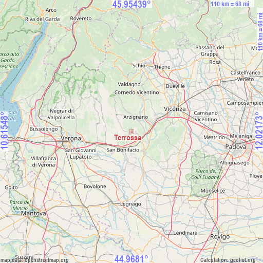
Terrossa GPS coordinates[2]
45° 27' 48.24" North, 11° 19' 6.96" East
| Map corner | latitude | longitude |
|---|---|---|
| Upper-left | 45.95439°, | 10.61548° |
| Center: | 45.4634°, | 11.3186° |
| Lower-right: | 44.9681°, | 12.02173° |
| Map W x H: | 109.7×109.7 km | = 68.2×68.2mi |
| max Lat: | 47.04031° ⇑27.7% North |
| Terrossa: | 45.4634° |
| min Lat: | ⇓72.3% South 35.50142° |
| min Long | Terrossa | max Long |
| 6.69888° | 11.3186° | 18.48682° |
| W 47.1%⇐ | ⇒52.9% E |
Elevation
Elevation of Terrossa is 49 m = 161 ft, and this is 257.7 m = 845 ft below average elevation for this country.
| Max E: |
2085 m = 6841 ft | 80.1% |
| Avg. | 306.7 m = 1006 ft | |
| Terrossa | 49 m = 161 ft | |
Min E: |
-4 m = -13 ft | 19.9% |
See also: Italy elevation on elevation.city.
Geographical zone
Terrossa is located in North temperate zone (between Tropic of Cancer and the Arctic Circle). Distance of this North polar circle is 2346.1 km =1457.8 mi to North.| Distance of | km | miles | from Terrossa |
|---|---|---|---|
| North Pole | 4952 | 3077 | to North |
| Arctic Circle | 2346.1 | 1457.8 | to North |
| Tropic Cancer | 2449.1 | 1521.8 | to South |
| Equator | 5055.1 | 3141.1 | to South |


Nearby cities:
15 places around Terrossa: (largest is in red/bold)
• Arzignano
6.4 km =4 mi,  11°
11°
• Brognoligo-Costalunga
2.5 km =1.6 mi,  229°
229°
• Gambellara
1.7 km =1.1 mi,  103°
103°
• Locara
5.8 km =3.6 mi,  169°
169°
• Meledo
8.1 km =5 mi,  110°
110°
• Montebello Vicentino
5 km =3.1 mi, 95°
• Montecchia di Crosara
5.4 km =3.4 mi,  292°
292°
• Monteforte d'Alpone
5.5 km =3.4 mi,  208°
208°
• Monticello di Fara
6.8 km =4.2 mi,  124°
124°
• Montorso Vicentino
4.5 km =2.8 mi,  46°
46°
• Roncà
2.7 km =1.7 mi,  312°
312°
• San Bonifacio
8.3 km =5.2 mi, 205°
• San Vittore
8.4 km =5.2 mi,  243°
243°
• Soave
7.5 km =4.7 mi, 229°
• Zermeghedo
4.6 km =2.9 mi,  72°
72°
Sources, notices
• [Note1] Compared only with cities in Italy existing in our database
• [Src1] Map data: © OpenStreetMap contributors (CC-BY-SA)
• [Src2] Other city data from geonames.org with taken over terms of usage.
• [Src3] Geographical zone / Annual Mean Temperature by Robert A. Rohde @ Wikipedia
