Zermeghedo geodata
Zermeghedo (Veneto) is a seat of a third-order administrative division; located in Italy in Europe/Rome (GMT+2) time zone. With population of 1,245 people, there are 5808 cities with bigger population in this country. Compared to other cities in Italy, 72.7% of cities are located further ↓South; 52.2% of cities are located further →East and 77.5% of cities have higher elevation than Zermeghedo. Note1


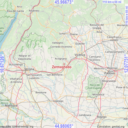
Zermeghedo GPS coordinates[2]
45° 28' 33.06" North, 11° 22' 27.768" East
| Map corner | latitude | longitude |
|---|---|---|
| Upper-left | 45.96673°, | 10.67126° |
| Center: | 45.47585°, | 11.37438° |
| Lower-right: | 44.98065°, | 12.07751° |
| Map W x H: | 109.6×109.6 km | = 68.1×68.1mi |
| max Lat: | 47.04031° ⇑27.3% North |
| Zermeghedo: | 45.47585° |
| min Lat: | ⇓72.7% South 35.50142° |
| min Long | Zermeghedo | max Long |
| 6.69888° | 11.37438° | 18.48682° |
| W 47.8%⇐ | ⇒52.2% E |
Elevation
Elevation of Zermeghedo is 62 m = 203 ft, and this is 244.7 m = 803 ft below average elevation for this country.
| Max E: |
2085 m = 6841 ft | 77.5% |
| Avg. | 306.7 m = 1006 ft | |
| Zermeghedo | 62 m = 203 ft | |
Min E: |
-4 m = -13 ft | 22.5% |
See also: Italy elevation on elevation.city.
Geographical zone
Zermeghedo is located in North temperate zone (between Tropic of Cancer and the Arctic Circle). Distance of this North polar circle is 2344.7 km =1456.9 mi to North.| Distance of | km | miles | from Zermeghedo |
|---|---|---|---|
| North Pole | 4950.6 | 3076.2 | to North |
| Arctic Circle | 2344.7 | 1456.9 | to North |
| Tropic Cancer | 2450.5 | 1522.7 | to South |
| Equator | 5056.4 | 3141.9 | to South |


Nearby cities:
15 places around Zermeghedo: (largest is in red/bold)
• Arzignano
5.8 km =3.6 mi,  327°
327°
• Brendola
5.1 km =3.2 mi,  86°
86°
• Brognoligo-Costalunga
7 km =4.3 mi,  244°
244°
• Gambellara
3.2 km =2 mi, 236°
• Locara
7.8 km =4.8 mi,  204°
204°
• Meledo
5.3 km =3.3 mi,  142°
142°
• Montebello Vicentino
2 km =1.2 mi,  160°
160°
• Montecchio Maggiore-Alte Ceccato
4.3 km =2.7 mi,  43°
43°
• Monticello di Fara
5.4 km =3.4 mi,  166°
166°
• Montorso Vicentino
2 km =1.2 mi, 326°
• Roncà
6.3 km =3.9 mi,  274°
274°
• Tavernelle
7.2 km =4.5 mi,  53°
53°
• Terrossa
4.6 km =2.9 mi,  252°
252°
• Tezze
6.5 km =4 mi,  356°
356°
• Vo
5.9 km =3.7 mi,  111°
111°
Sources, notices
• [Note1] Compared only with cities in Italy existing in our database
• [Src1] Map data: © OpenStreetMap contributors (CC-BY-SA)
• [Src2] Other city data from geonames.org with taken over terms of usage.
• [Src3] Geographical zone / Annual Mean Temperature by Robert A. Rohde @ Wikipedia
